TRMM KEEPS AN EYE ON HURRICANE ISABEL
animations:
small (2 MB MPEG)
large (5 MB QuickTime)
Hurricane Isabel is now the second major hurricane of the 2003 Atlanticseason. Like Hurricane Fabian before it, Isabel originated in the easternAtlantic from an easterly wave coming off of the coast of Africa and isknown as a "Cape Verde" storm. Cape Verde storms are more prominant in themiddle part of the hurricane season as sea surface temperatures become morefavorable for development in that part of the Atlantic.
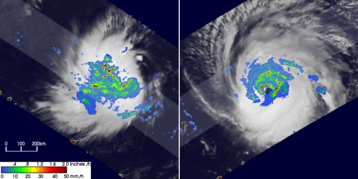
The Tropical Rainfall Measuring Mission (TRMM) satellite is a valuable tool for examining hurricanes especially when they are far out to sea where observations arelimited. TRMM captured these two images of Isabel as it tracked across thecentral Atlantic.
The first image was taken at 07:18 UTC (03:18 am AST) on 6 September 2003 just as Isabel was getting organized into a tropical storm. At the time, the system was located 600 miles west of the Cape Verde Islandsand within hours would be named a tropical storm by the National Hurricane Center with winds estimated at 40 mph. The image provides a top down view of the storm with rainfall rates from the TRMM Precipitation Radar (PR) inthe inner swath and the TRMM Microwave Imager (TMI) in the outer swath overlaid on TRMM Visible Infrared Scanner (VIRS) data (white areas). It shows that the rainfall pattern is very asymmetrical and that the system does not yet have a closed eye. However, the VIRS data shows that conditions are favorable for further development. That is, thestorm has good outflow as evidenced by the cirrus outflow especially on thenorthern, western and southern sides of the storm.
The second image taken just a coupleof days later on 8 September at 21:56 UTC (5:56 pm AST) shows Isabel hadstrengthened into a major hurricane. It is now very well organized with awell-defined eye and good banding evident in the rainfield (green areas).The PR shows that there is heavy rainfall all along the western and northerneye wall (red and green areas) providing the heat energy that fuels the storm.The VIRS data also shows excellent outflow to all quadrants meaning conditionscontinue to be favorable for further strengthening. At this time, Isabelwas a Category 3 hurricane with winds estimated at 125 mph and was located1200 miles east of the Leeward Islands. Isabel would later become aCategory 4 storm with winds estimated at 135 mph by the National HurricaneCenter.
References & Resources
Image produced by Hal Pierce (SSAI/NASA GSFC) and caption by Steve Lang (SSAI/NASA GSFC).