


large images:
September 12, 2002 (1.3 MB JPEG)
September 28, 2002 (1.3 MB JPEG)
Difference between September 28th and 12th (390 KB JPEG)
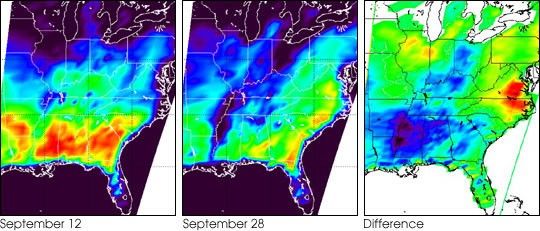
The images above are from the Advanced Microwave Sounding Unit (AMSU) onboard NASA’s Aqua spacecraft. The left image was taken on September 12,about two weeks prior to the landfall of Tropical Storm Isidore alongthe Louisiana coast, while the image in the middle was taken onSeptember 28, about a day after Isidore made landfall. The difference inthe two microwave images in the vicinity of Mississippi is primarily dueto flooding caused by Tropical Storm Isidore. The image from September28 shows heavy flooding along the Mississippi River, especially in thestates of Mississippi and Tennessee. Since water has a very low surfaceemissivity at the microwave wavelength being used for these images,surface water appears to be very cold. Land appears relatively warm(well above freezing even at night as seen in these images), but inlocations with standing water the apparent temperature dropsprecipitously. The spatial resolution of the AMSU instrument isrelatively large (each measurement spot is about 40.5 km, or 25 miles indiameter at the center of the swath), but the enormous thermal contrastin the microwave between land and water makes even small flooded areasstand out.
The Aqua spacecraft has an exact 16-day repeat cycle, hence by usingimages 16-days apart, the two images have exactly the same spatialcoverage, which makes it convenient to obtain the difference between theSeptember 28 and September 12 images. In the difference image (shown atthe far right), white indicates no difference, green indicates verylittle difference, and blue/purple indicates primarily heavy flooding.Red indicates warming likely due to higher air temperatures. (Thestraight lines on the right and left edges of the difference image arecaused by slight differences between the two repeat passes of Aqua.)
References & Resources
The images and an earlier version of the text were provided by the AIRS Science Team, which is the focus for the science being done with the three Aqua sounders: the Atmospheric Infrared Sounder (AIRS), the Humidity Sounder for Brazil (HSB), and the AMSU.
None


