


September 19, 2015-September 3, 2021
Hurricanes Have Left Their Mark on Louisiana’s Wetlands
Exactly 16 years after Hurricane Katrina made landfall in southern Louisiana, another major hurricane blew into the state. On August 29, 2021, Hurricane Ida came ashore at Port Fourchon with sustained winds of 150 miles (240 kilometers) per hour. The tide surged in some places up to 14 feet above sea level and slammed into marshes and swamps west of the Mississippi River, eroding soil and vegetation.
“Wetlands in southern Louisiana have taken a real beating from hurricanes in recent years,” said Chris Potter, an ecologist at NASA’s Ames Research Center. Although multiple natural and human-caused processes contribute to land loss along the coast, Potter has observed signatures of lasting storm damage after some of the strongest storms—especially Hurricanes Ida (2021) and Katrina (2005).
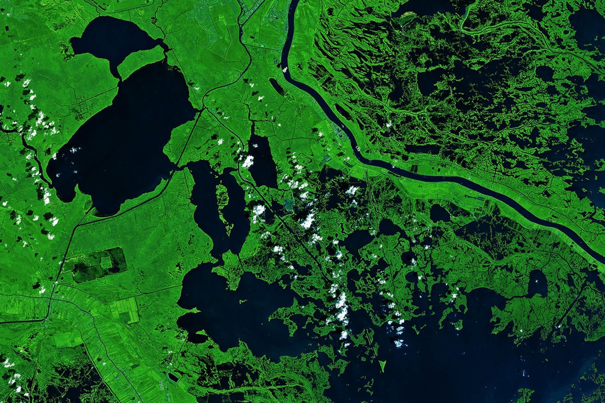
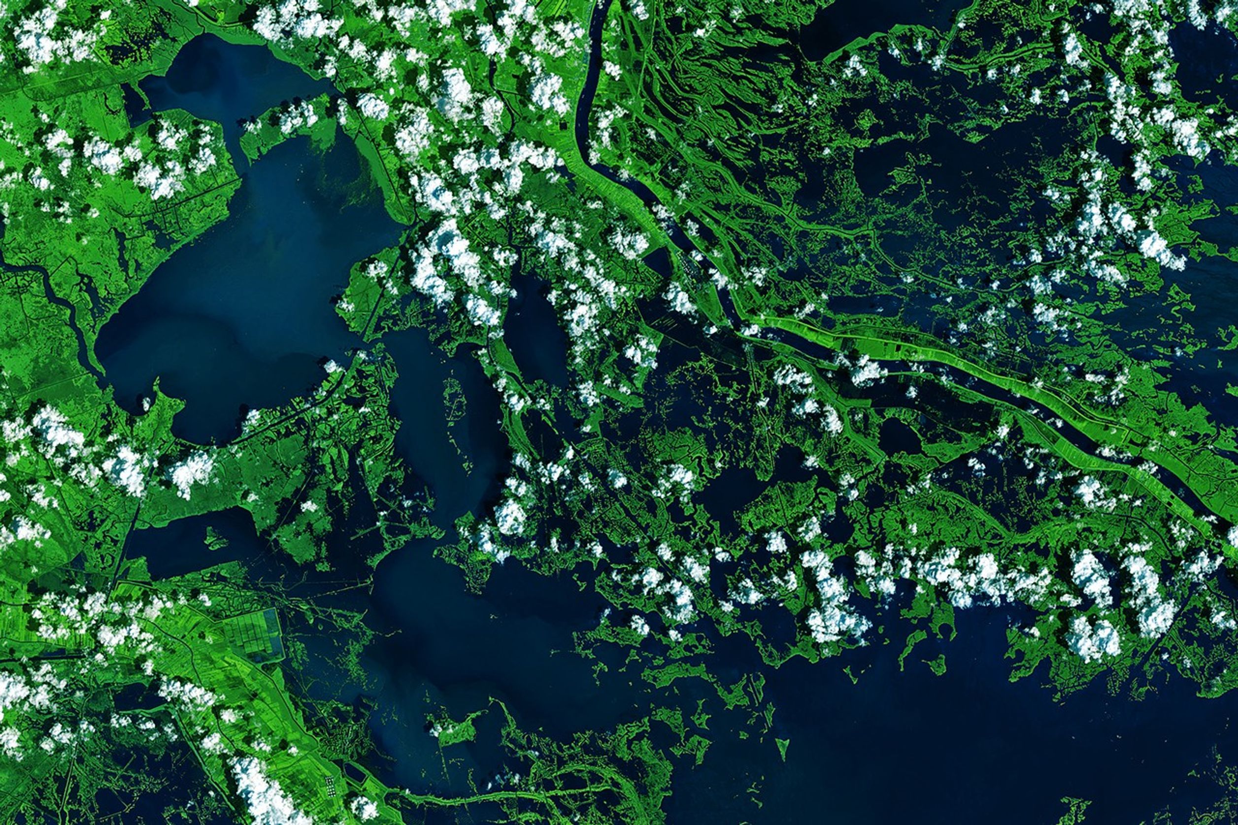
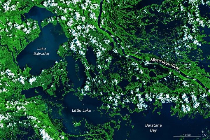
In a recent study, Potter documented wetland loss in Louisiana between 2000 and 2022 using data from the Landsat satellites. In 2021, Hurricane Ida was especially destructive to the marshlands and swamplands of Barataria Basin, just inland from Barataria Bay. The images above show Barataria Basin in September 2015 (left) compared to September 2021 (right), just after Hurricane Ida hit. Green vegetation in the wetlands around Little Lake turned to open water.
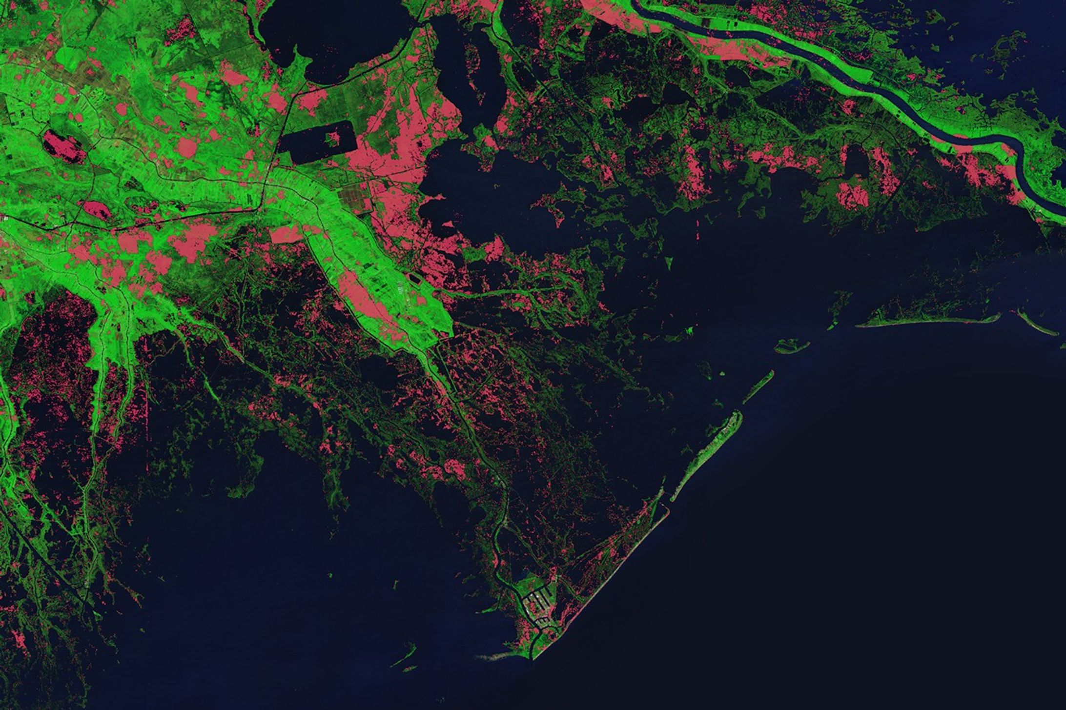
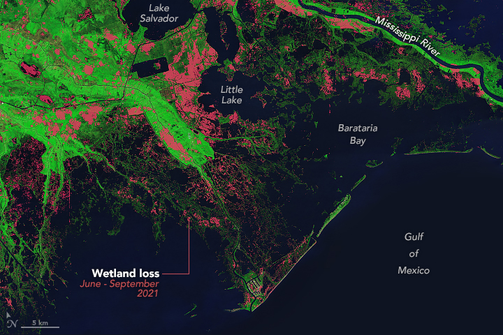
Potter found that following Ida, more than 680 square kilometers of wetlands in Barataria Basin and Terrebonne Basin (west of Barataria Bay) transformed into open water. The map below shows where wetlands in southern Louisiana disappeared after Ida, as calculated by Potter comparing Landsat data from June 2021 to September 2021. The analysis looked at the difference between pixels identified as water before and after Ida. Land loss occurred along most of the southern-facing shorelines of the Barataria Basin.
Oil and gas exploration, oil spills, rising sea levels, and subsidence also contribute to land loss in the region. Potter found that, in addition to tropical storms, oil pollution left behind from the Deepwater Horizon spill in 2010 contributed to wetland degradation in Barataria Basin. The presence of oil likely damaged the marsh’s vegetation above and below the ground, reducing the stability of the surrounding soil and making the marsh more vulnerable to erosion. Heavily oiled wetlands experienced more loss than those that were less polluted, according to Potter. He noted that oil residues were still present in the basin in 2023.
Southern Louisiana’s coast is a latticework of shrinking marshes, swamps, and barrier islands. No other coastline in the contiguous United States has changed as much in recent decades. By one estimate, Louisiana lost approximately 4,800 square kilometers of land from 1932 to 2016—an area that amounts to approximately 25 percent of the state’s 1932 extent.
Prior to Hurricane Katrina, much of the land lost in coastal Louisiana was due to oil and gas exploration and subsidence, said Potter, rather than tropical storms. He attributed the extent of recent topical storms’ damage on wetlands to their increased strength. According to the National Climate Assessment, the intensity of hurricanes in the North Atlantic has increased since the 1980s. “Category 4 or 5 storms were quite rare in the Gulf Coast until recently,” said Potter. “Now every couple of years we get them.” There is also growing consensus among scientists that in a warmer world, with higher sea surface temperatures, tropical storms in the Atlantic will get stronger still.
Louisiana is working to restore and rebuild marshes and swamps that dampen storm surge from hurricanes. One method is constructing sediment diversions that aim to replenish sediment and nutrients to coastal wetlands. Potter said that by using data from Landsat satellites, scientists can monitor the benefits of such projects.
References & Resources
- NASA Earth Observatory (2021, September 11) A Changed Landscape in Southern Louisiana. Accessed May 10, 2024.
- NASA Earth Observatory (2021, January 4) Reshaping Coastal Louisiana. Accessed May 10, 2024.
- Potter, C., & Sukanna, T. (2024) Remote Sensing of Damage Inflicted on Coastal Wetlands of Southern Louisiana from Tropical Storms. Journal of Coastal Research, 40(2), 235-245.
- U.S. Geological Survey (2017) Land Area Change in Coastal Louisiana (1932 to 2016). Accessed May 10, 2024.
- U.S. Global Change Research Program, Crimmins, A.R., C.W. Avery, D.R. Easterling, K.E. Kunkel, B.C. Stewart, and T.K. Maycock, Eds. (2023) Fifth National Climate Assessment. Accessed May 10, 2024.
NASA Earth Observatory image by Michala Garrison, using Landsat data from the U.S. Geological Survey and Potter, C. and Sukanna, T., (2023) . Story by Emily Cassidy .