


Heavy rains and swiftly warming temperatures followed a prolonged cold spell in the Northeastern U.S., leading to a long ice jam that clogged the Connecticut River. The Moderate Resolution Imaging Spectroradiometer (MODIS) on NASA’s Terra satellite collected natural-color (left) and false-color (right) images of the ice on January 18, 2018. In the false-color image, ice appears light blue, and open water appears black. A second large jam is visible south of Haddam, Connecticut.
On the same day, the Multi Spectral Imager (MSI) on the European Space Agency’s Sentinel-2 satellite acquired the data for a natural-color image (below) of the ice jam. Iced-over parts of the river are white; open water is green.
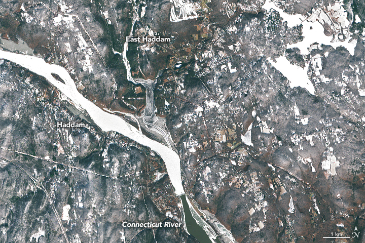
The ice jam extended several miles upstream from Haddam. Much of it was made up of brash ice—a sturdy type that forms when thinner ice layers are pushed on top of each other and then frozen together by cold weather. Often brash ice on rivers includes tree limbs and other debris that make it difficult for ice cutters to break it.
Three U.S. Coast Guard cutters capable of breaking ice are working in the area. Cheers went up from the shores of the river as the boats arrived and began to break up the jam on January 23, the Coast Guard tweeted.
Ice jams can block the natural flow of rivers and cause water levels to rise behind them.On January 23, the river level was 7 feet (2 meters) at Middle Haddam—high enough to cause minor flooding. National Weather Service forecasters expect the river to crest at 8.5 feet (2.6 meters) on January 24.
References & Resources
- Hartford Courant (2018, January 23) Coast Guard Ice Cutters Reach East Haddam Swing Bridge. Accessed January 23, 2018.
- Hartford Courant (2018, January 19) Coast Guard Cutters Battle Ice-Locked Connecticut River. Accessed January 23, 2018.
- Molloy, T. East Haddam Swing Bridge Ice Jam. Accessed January 23, 2018.
- NOAA (2018, January 23) Connecticut River at Middle Haddam. Accessed January 23, 2018.
- NOAA (2018, January 23) Flood Warning. Accessed January 23, 2018.
- Scijinks (2017) What is an ice jam? Accessed January 23, 2018.
- The Middletown Press (2018, January 18) Haddam official declares emergency as colossal ice jam clogs Connecticut River. Accessed January 23, 2018.
- The Northeast States Emergency Consortium Ice Jams. Accessed January 23, 2018.
NASA Earth Observatory image by Joshua Stevens, using MODIS data from LANCE/EOSDIS Rapid Response , and modified Copernicus Sentinel data (2018) processed by the European Space Agency. Caption by Adam Voiland.


