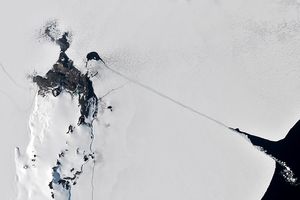
Filaments of sea ice trace ocean currents, creating swirls visible along the coast of Labrador, in eastern Canada. The dazzling display of frozen seawater was captured by satellite sensors and an astronaut on the International Space Station.
As sea ice at far northern latitudes approached its maximum annual extent, the MODIS (Moderate Resolution Imaging Spectroradiometer) instrument on NASA’s Terra satellite captured this image of the Labrador Sea on February 3, 2024. Situated between Canada’s Labrador Peninsula and Greenland, the sea is part of the North Atlantic Ocean and connects to the Arctic Ocean via various straits and bays to the north. Swirls of smaller sea ice pieces churned along the crumbling edge of the more consolidated ice pack off the coast of Labrador Inuit Lands, in the Newfoundland and Labrador province.
Ocean currents can stir ice chunks into circular vortices, or eddies. Eddies form frequently along boundaries between cold and warm ocean currents in the spring and fall, due to differences in water density. Even then, however, an ice eddy won’t form except under certain conditions: it must be warm enough for the ice to fragment, but cool enough for it to remain frozen.
The International Space Station affords astronauts the opportunity to observe processes that are impossible to see from the ground. The whirling ice eddies caught the eye of an astronaut on the station, who took the photo below on the same day that NASA’s MODIS on the Terra satellite captured the image above. This side, or limb, view of Earth in the astronaut’s photo shows the ice swirls in the center, and part of the planet’s atmosphere (blue) in the upper-right.

According to the National Snow and Ice Data Center, sea ice growth throughout the Arctic region—including the Labrador Sea—has been slower than usual for the end of January. The Gulf of St. Lawrence, on the eastern coastline of Newfoundland and Labrador, would normally contain more sea ice this time of year. But as of the end of January, the area was mostly open water.
References & Resources
- NASA Earth Observatory (2023, December 24) Sea Ice Delivery from the Arctic Circle. Accessed February 14, 2024.
- NASA Earth Obsevatory (2023, March 22) Arctic Sea Ice Below Average in Winter 2023. Accessed February 14, 2024.
- NASA Earth Observatory (2016, July 21) Swirls of Ice in the Labrador Sea. Accessed February 14, 2024.
- National Snow and Ice Data Center (2024, February 5) Nothing Swift about January’s Arctic sea ice. Accessed February 14, 2024.
NASA Earth Observatory image by Michala Garrison, using MODIS data from NASA EOSDIS LANCE and GIBS/Worldview . Astronaut photograph ISS070-E-86805 was acquired on February 3, 2024, with a Nikon D5 digital camera using a 135 millimeter lens and is provided by the ISS Crew Earth Observations Facility and the Earth Science and Remote Sensing Unit, Johnson Space Center. The image was taken by a member of the Expedition 70 crew. The image has been cropped and enhanced to improve contrast, and lens artifacts have been removed. The International Space Station Program supports the laboratory as part of the ISS National Lab to help astronauts take pictures of Earth that will be of the greatest value to scientists and the public, and to make those images freely available on the Internet. Additional images taken by astronauts and cosmonauts can be viewed at the NASA/JSC Gateway to Astronaut Photography of Earth . Story by Emily Cassidy .