

December 20, 2023-February 5, 2024
Inferno Scars Valparaíso
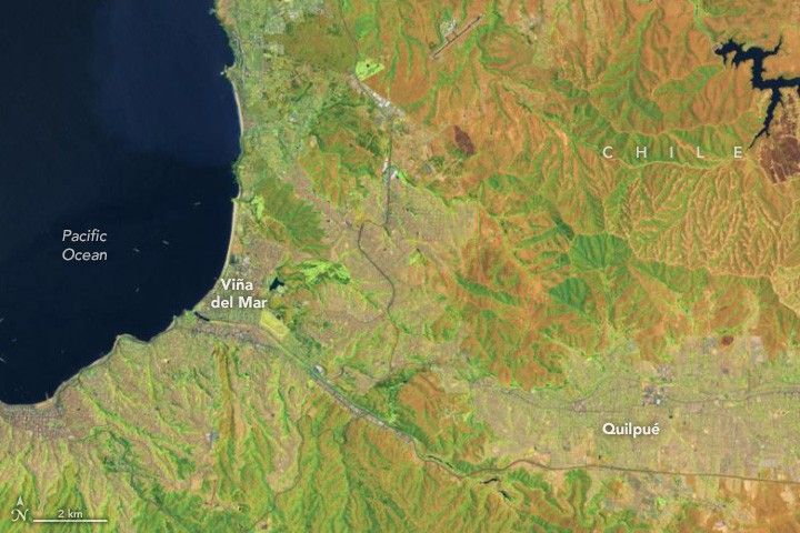
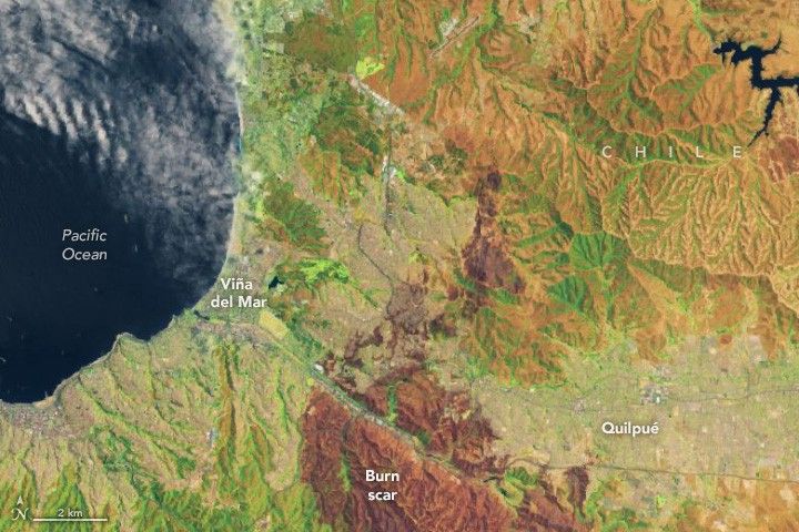
What is thought to be Chile’s deadliest outbreak of wildland fire on record scorched portions of the cities of Viña del Mar and Quilpué in the country’s Valparaíso region in February 2024.
NASA satellites first observed fires in wilderness areas in hills to the south of the two cities on February 2, 2024. During the next two days, fires descended from the hills and tore through stream valleys that run through the cities, at times spreading into residential areas and consuming entire streets and neighborhoods.
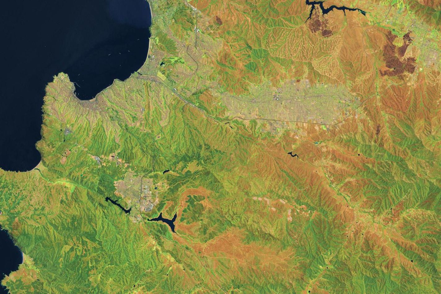
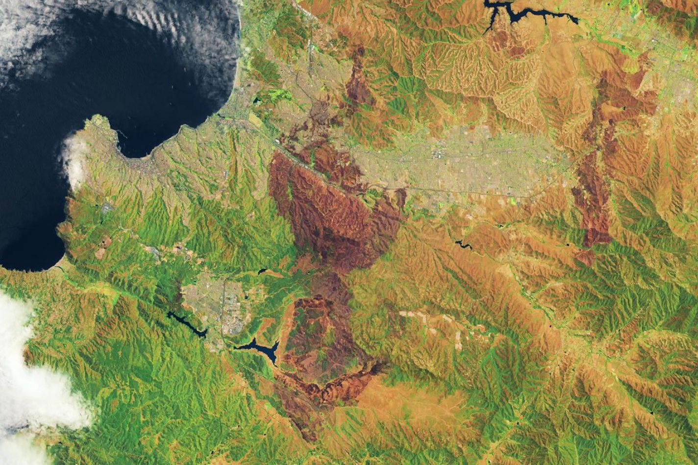
The OLI-2 (Operational Land Imager-2) on Landsat 9 captured this false-color image of the charred landscape left after the fire on February 5, 2024 (right image). With this combination of shortwave infrared, near infrared, and visible observations (bands 6-5-3), lands with unburned forests, brushlands, or grasslands appear green. Developed areas appear pink or gray; developed areas that burned are darker than the unaffected parts of the cities. The image on the left, captured by the OLI (Operational Land Imager) on Landsat 8, shows the same area before the fires happened.
“These catastrophic wildfires were the product of a perfect storm of conditions,” said Elizabeth Wiggins, a research scientist at NASA’s Langley Research Center who works with NASA’s Earth Applied Sciences Disasters program area. “They occurred during a heatwave, drought, and high-wind event borne from a combination of El Niño and climate change.”
The fires came in the midst of an extreme drought that primed the region’s vegetation for burning. This was exacerbated by a dry heat wave that sent temperatures soaring in early February and a period of strong winds that pushed conditions to the breaking point.
“The extreme weather—especially the wind—appears to have led to rapid spread and transformed this from an ordinary fire into a firestorm with tragic consequences,” said atmospheric scientist René Garreaud of the University of Chile. A preliminary analysis conducted by Garreaud showed that average wind speeds reached 25 knots (46 kilometers/29 miles per hour) at Rodelillo Airfield on February 2.
The inferno charred at least 290 square kilometers (112 square miles) and damaged or destroyed more than 14,000 buildings, according to news reports. As of February 8, 2024, authorities had recorded 131 deaths, and hundreds of people were still missing. That made this the fifth deadliest fire globally since 1900, according to the International Disaster database EM-DAT.
“Fast-moving wildfires driven by extreme wind and drier fuels than usual are exceptionally dangerous and almost impossible to fight,” Wiggins said. “It is notable and alarming that we are seeing these types of fires occur more frequently across distinct ecosystems around the globe, from the boreal forest to the chaparral.” Similar wind-driven fires devastated parts of Colorado in 2021 and Maui in August 2023.
“Researchers in the fire science community are actively studying this new breed of fire and looking for ways to predict periods of rapid growth and intensification,” Wiggins added. “Learning how to mitigate these fires is going to require an ‘all hands on deck’ approach, with collaboration across agencies and borders.”
NASA’s Earth Applied Sciences Disasters program area has been activated to support partners responding to the event. As new information becomes available, the team will be posting maps and data products on its open-access mapping portal.
Among the data available are maps of fire perimeters from NASA’s Fire Event Data Suite, or FEDS, system. The system, developed as part of NASA’s Earth Information System, draws data from VIIRS (Visible Infrared Imaging Radiometer Suite) satellite sensors to track how a fire changes over time and the total area it has burned.
“In a twelve-hour period between the afternoon of February 2 and early morning hours of February 3, FEDS revealed a nearly fivefold increase in the area affected by the largest fire in Valparaiso,” said Eli Orland, a research associate at Goddard Space Flight Center and the University of Maryland, Baltimore County. “The affected area coincides with areas of variable and steep topography, which increases the likelihood of post-fire debris flows and flash flooding occurring, even during routine rainfall events.”
References & Resources
- CBS News (2024, February 5) Satellite images show scale of Chile deadly wildfires, destroyed neighborhoods. Accessed February 8, 2024.
- Copernicus (2024) Wildfire in Valparaiso region, Chile. Accessed February 8, 2024.
- El País (2024, February 7) Why the fires in Chile destroyed so many lives. Accessed February 8, 2024.
- European Commission (2024, February 7) Daily Flash. Accessed February 8, 2024.
- International Charter Space & Major Disasters (2024, February 2) Wildfire in Chile. Accessed February 8, 2024.
- National Integrated Drought Information System Global Drought Conditions. Accessed February 8, 2024.
- NASA Disasters Program (2024) Chile Wildfires. Accessed February 8, 2024.
- ReliefWeb (2024) Chile: Wild Fires - Jan 2024. Accessed February 8, 2024.
- SENAPRED (2024, February 6) Undersecretary Monsalve delivered a new balance sheet for forest fires and announced support measures. Accessed February 8, 2024.
- The Washington Post (2024, February 5) Massive wildfires are a new threat to Chile. Here’s why they’re so deadly. Accessed February 8, 2024.
- Yale Climate Connections (2024, February 6) Chile’s wildfire death toll rises above 130. Accessed February 8, 2024.
- World Meteorological Organization (2024, February 5) Wildfires cause huge loss of life in Chile amid heatwaves in South America. Accessed February 8, 2024.
NASA Earth Observatory images by Wanmei Liang , using Landsat data from the U.S. Geological Survey . Story by Adam Voiland .