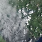
The June 27th lava flow—named for the day it began erupting from a vent on Kilauea’s Pu‘u ‘O’o crater—continues to move northeast through Puna Forest Reserve. The Advanced Land Imager (ALI) on the Earth Observing-1 (EO-1) satellite captured this image of lava burning through forest on September 11, 2014. The flow was within 0.6 kilometers (0.4 miles) of the Kaohe Homesteads development when EO-1 acquired the image. Houses in Kaohe Homesteads appear as white dots on the right side of the image.
During an aerial survey on September 10, the Hawaiian Volcano Observatory captured the lower photograph. It shows the Kaohe Homesteads in the foreground, with smoke plumes from the lava flow rising in the distance.
References & Resources
- Hawaii News Now (2014, September 12) Puna lava flow impact on Pahoa ‘inevitable’. Accessed September 12, 2014.
- NASA Earth Observatory Volcanic Activity at Kilauea. Accessed September 12, 2014.
- Smithsonian Institution Global Volcanism Program (2014, September 12) Kilauea. Accessed September 12, 2014.
- U.S. Geological Survey Hawaiian Volcano Observatory (2014, September 12) Recent Kilauea Status Reports, Updates, and Information Releases. Accessed September 12, 2014.
NASA Earth Observatory image by Jesse Allen, using EO-1 ALI data provided courtesy of the NASA EO-1 team and the U.S. Geological Survey. Aerial photograph of the U.S. Geological Survey Hawaiian Volcano Observatory. Caption by Adam Voiland.