Suggested Searches

1 min read

Landsat 7 Views Mozambique Flooding

Topics:
Landsat 7 Views Mozambique Flooding

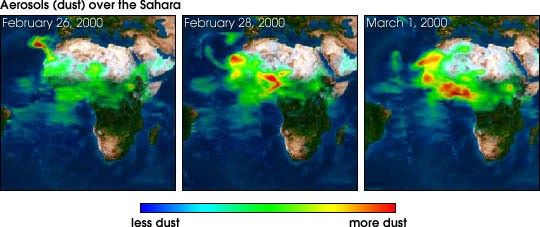
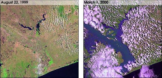
This pair of images from Landsat 7 shows the incredible amount of flooding that is currently occuring in Mozambique. A month of rains and two cyclones caused the Limpopo River to swell to 80km wide in places. At least several hundredpeople have been killed, and over a million have been forced from their homes.

For more background information, see the Landsat 7 fact sheetand Floods: Using Satellites to Keep our Heads Above Water

References & Resources

Image courtesy of Landsat 7 project

None

You may also be interested in:

Stay up-to-date with the latest content from NASA as we explore the universe and discover more about our home planet.

Dry-Season Floods Drench Northern Colombia
3 min read

Villages and farmland were swamped after unusually heavy early-February rains pushed the Sinú River over its banks.

Article
Floods Inundate Southern Mozambique
2 min read

Weeks of intense rain overwhelmed rivers and reservoirs, displacing hundreds of thousands of people.

Article
Senyar Swamps Sumatra
3 min read

A rare tropical cyclone dropped torrential rains on the Indonesian island, fueling extensive and destructive floods.

Article