


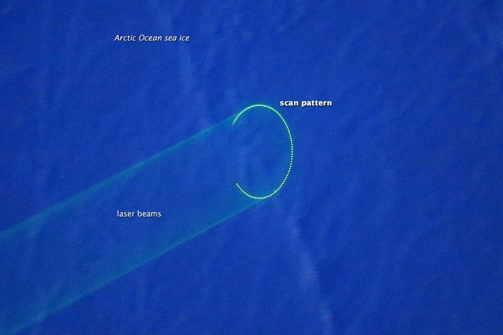
Every spring, NASA’s Operation IceBridge makes two flights across the North American side of the Arctic Ocean—north of Greenland, Canada, and all the way to Alaska, then and back again—for a look at the sea ice. This photograph was acquired by the Digital Mapping System (DMS)—a camera that looks straight on the terrain below the plane—during one of those flights on April 1, 2015.
According to sea ice scientist Sinead Farrell, the image shows typical, mildly deformed first-year sea ice. Small pressure ridges and sastrugi (snow dunes) are visible on the surface. What's uncommon about the image, however, is that it was captured during first few hours of twilight. The lack of sunlight provided an opportunity for the DMS to get a glimpse of laser beams scanning the sea ice. Next to the DMS in the belly of the plane, the Airborne Topographic Mapper (ATM) sends pulses of laser light off of a rotating mirror and onto the ice below. This photo shows the elliptical scan pattern of the ATM as it made 94 laser shots in the one-thirtieth of a second that the DMS camera shutter was open.
By timing the round-trip journey of the light pulses and accounting for the location and altitude of the plane, scientists can determine the height of the ice surface. Flying the same path every year provides detailed information about how the surface height of the ice has changed. This information in turn contributes to calculations of sea ice thickness in these areas, which scientists have shown to be thinning.
References & Resources
- NASA Earth Science News Team (2014, March 31) NSIDC, NASA Say Arctic Melt Season Lengthening, Ocean Rapidly Warming. Accessed April 3, 2015.
- Polar Trec (2014, April 8) Everyone Likes Lasers ... Right?. Accessed April 3, 2015.
NASA image courtesy Eric Fraim, Digital Mapping System . Caption by Kathryn Hansen.


