
May 14-June 7, 2018
Lava Consumes Vacationland and Kapoho Bay
Steaming fissures first began to crack open and spread lava across Hawaii’s Leilani Estates neighborhood on May 3, 2018. Since then, more than 20 fissures have opened on Kilauea’s Lower East Rift Zone, though most of the lava flows have been small and short-lived.
Not so for fissure number 8. That crack in the Earth has been regularly generating large fountains of lava that soar tens to hundreds of feet into the air. It has produced a large, channelized lava flow that has acted like a river, eating through the landscape as it flows toward the sea.
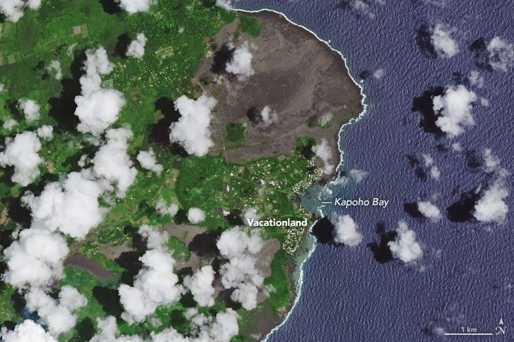
While the fissure 8 lava flow initially remained in relatively narrow channels, it began to widen significantly as it neared the coastline and passed over flatter land. It evaporated Hawaii’s largest lake in a matter of hours, and devastated the communities of Vacationland and Kapoho, destroying hundreds of homes.
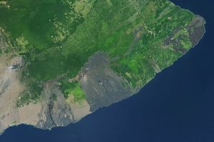
On June 3, 2018, lava from fissure 8 reached the ocean at Kapoho Bay on Hawaii’s southeast coast. When the Multi-Spectral Instrument (MSI) on the European Space Agency’s Sentinel-2 satellite captured a natural-color image on June 7, the lava had completely filled in the bay and formed a new lava delta. For comparison, the Landsat 8 image shows the coastline on May 14.
Since May 3, 2018, Kilauea has erupted more than 110 million cubic meters of lava. That is enough to fill 45,000 Olympic-sized swimming pools, cover Manhattan Island to a depth of 2 meters (7 feet), or fill 11 million dump trucks, according to estimates from the U.S. Geological Survey. However, that is only about half of the volume erupted at nearby Mauna Loa in a major eruption in 1984.
The new land at Kapoho Bay is quite dynamic, fragile, and dangerous. “Venturing too close to an ocean entry on land or the ocean exposes you to flying debris from sudden explosive interaction between lava and water,” USGS warns. Since lava deltas are built on unconsolidated fragments and sand, the loose material can abruptly collapse or quickly erode in the surf.
The plumes that form where lava meets seawater are also hazardous. Sometimes called “laze,” these white plumes of hydrochloric acid gas, steam, and tiny shards of volcanic glass can cause skin and eye irritation and breathing difficulties. When Sentinel-2 captured this image, the laze plume streamed west and mixed with clouds.
References & Resources
- Discover (2018, June 11) Rocky Planet: Over 500 Homes Now Destroyed by the Continuing Kilauea Eruption. Accessed June 12, 2018.
- Forbes (2018, June 6) Hawaii Volcano: Lava Flow Completely Fills The Beautiful Kapoho Bay. Accessed June 12, 2018.
- In the Company of Volcanoes (2018, May 3) Communicating volcanoes: resources for media. Accessed June 12, 2018.
- The New York Times (2018, June 9) 30 Billion Gallons of Hawaiian Lava,as Seen From the Ground and Space. Accessed June 12, 2018.
- NASA Disasters Program Mount Kilauea Eruption, Hawaii 2018. Accessed June 12, 2018.
- NASA Disasters Program Maps and Data for Kilauea. Accessed June 12, 2018.
- NASA Earth Observatory Volcanic Activity at Kilauea.
- Hawaii County Civil Defense Lava Flow Information. Accessed June 12, 2018.
- Star Advertiser (2018, June 8) Lava claims nearly 500 homes in Lower Puna. Accessed June 12, 2018.
- The Conversation (2018, June 5) From Kilauea to Fuego: three things you should know about volcano risk. Accessed June 12, 2018.
- U.S. Geological Survey Kilauea. Accessed June 12, 2018.
NASA Earth Observatory images by Joshua Stevens, using Landsat data from the U.S. Geological Survey and modified Copernicus Sentinel data (2018) processed by the European Space Agency. Story by Adam Voiland.