Evidence of the fiery history of the Sáttítla Highlands in Northern California can be seen in every direction. Volcanism has shaped the landscape over the past million years, and remnants of lava flows and eruptions remain visible today.
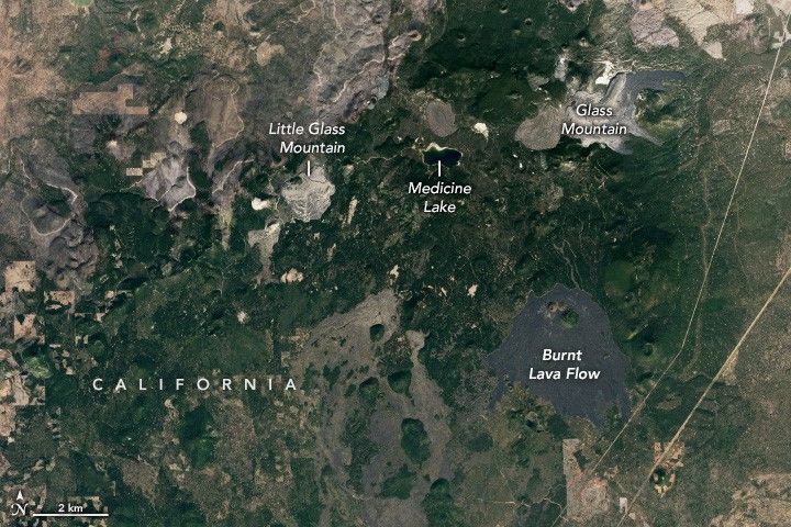
At Sáttítla’s core rests a sleeping giant: the Medicine Lake Volcano, one of the two largest volcanoes in the Cascades Volcanic Arc. Intermittent, mostly effusive (non-explosive) eruptions built this large shield volcano. The volcano’s central caldera cradles its namesake Medicine Lake, one of the many volcanic features visible in this image, acquired on October 7, 2024, by the OLI (Operational Land Imager) on Landsat 8.
The volcano has erupted nine times in the last 5,000 years, and some of those began with explosive phases. For example, two of the most recent eruptions sent ash tens of miles downwind before a slow effusion of thick lava (obsidian) formed Little Glass Mountain and Glass Mountain about 1,000 years ago. Glass Mountain’s steep-sided rhyolite and obsidian flow spans 14 square kilometers.
The Indigenous Ajumawi name “Sáttítla” translates to “obsidian place,” and the highlands contain portions of the ancestral homelands of Indigenous communities. On January 7, 2025, over 224,000 acres of these highlands were designated as a U.S. national monument, including portions of the homelands of the Pit River (Ajumawi – Atsugewi) and Modoc Peoples (Mo Wat Knii – Mo Docknii).
The image shows bare lava fields interspersed with islands of vegetation and surrounded by green forests. Sáttítla Highlands National Monument encompasses parts of the Modoc, Shasta-Trinity, and Klamath national forests. The region is home to rare and vulnerable flora and fauna, including the Cascades frog, the northern spotted owl, the long-toed salamander, and the sugarstick—a parasitic plant associated with the roots of old-growth conifers.
Over 80 plant species found here are used by Indigenous communities for medicine, food, tools, and ceremonial purposes. Obsidian tools have been found within the area, which were crafted by Indigenous communities throughout the region.
References & Resources
- Federal Register, Presidential Documents (2025, January 17) Establishment of the Sáttítla Highlands National Monument. Accessed January 17, 2025.
- NASA Earth Observatory (2017, October 17) Lava Beds National Monument. Accessed January 17, 2025.
- U.S. Forest Service (2025, January 14) Sáttítla Highlands National Monument. Accessed January 17, 2025.
- U.S. Geological Survey (2025, January 14) Medicine Lake Volcano part of newly designated Sáttítla Highlands National Monument. Accessed January 17, 2025.
- White House (2025, January 7) Fact Sheet: President Biden Establishes Chuckwalla and Sáttítla Highlands National Monuments in California. Accessed January 17, 2025.
NASA Earth Observatory image by Wanmei Liang , using Landsat data from the U.S. Geological Survey . Story by Emily Cassidy .