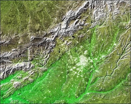
The white, mottled area in the right-center of this image from NASA’sShuttle Radar Topography Mission (SRTM) is Madrid, the capital of Spain.Located on the Meseta Central, a vast plateau covering about 40 percentof the country, this city of 3 million is very near the exact geographiccenter of the Iberian Peninsula. The Meseta is rimmed by mountains andslopes gently to the west and to the series of rivers that form theboundary with Portugal. The plateau is mostly covered with drygrasslands, olive groves and forested hills.
Madrid is situated in the middle of the Meseta, at an elevationof 646 meters (2,119 feet). To the northwest of Madrid, and visible in the upper left ofthe image, is the Sistema Central mountain chain that forms the “dorsalspine” of the Meseta and divides it into northern and southernsubregions. Rising to about 2,500 meters (8,200 feet), these mountainsdisplay some glacial features and are snow-capped for most of the year.Offering almost year-round winter sports, the mountains are alsoimportant to the climate of Madrid.
Three visualization methods were combined to produce this image:shading and color coding of topographic height and radar imageintensity. The shade image was derived by computing topographic slope inthe northwest-southeast direction. North-facing slopes appear bright andsouth-facing slopes appear dark. Color coding is directly related totopographic height, with green at the lower elevations, rising throughyellow and brown to white at the highest elevations. The shade image wascombined with the radar intensity image in the flat areas.
Size: 172 by 138 kilometers (107 by 86 miles)
Location: 40.43 degrees North latitude, 3.70 degrees West longitude
Orientation: North toward the top
Image Data: shaded and colored SRTM elevation model, with SRTM radar intensity added
Original Data Resolution: SRTM 1 arcsecond (about 30 meters or 98 feet)
Date Acquired: February 2000
References & Resources
Image Courtesy SRTM Team NASA/JPL/NIMA