


April 1, 2013-May 3, 2021
Mangroves Regrow in Iloilo City
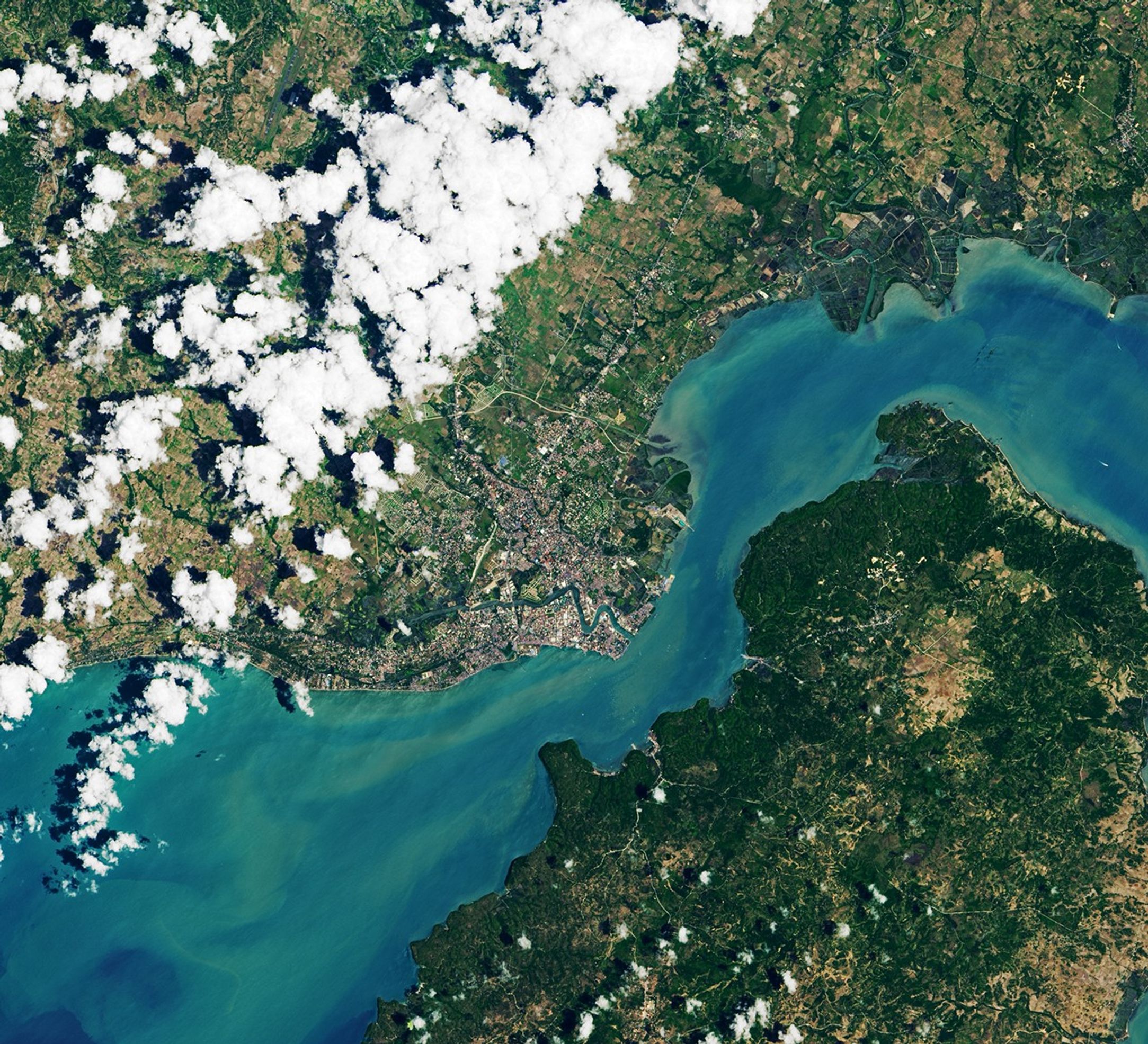
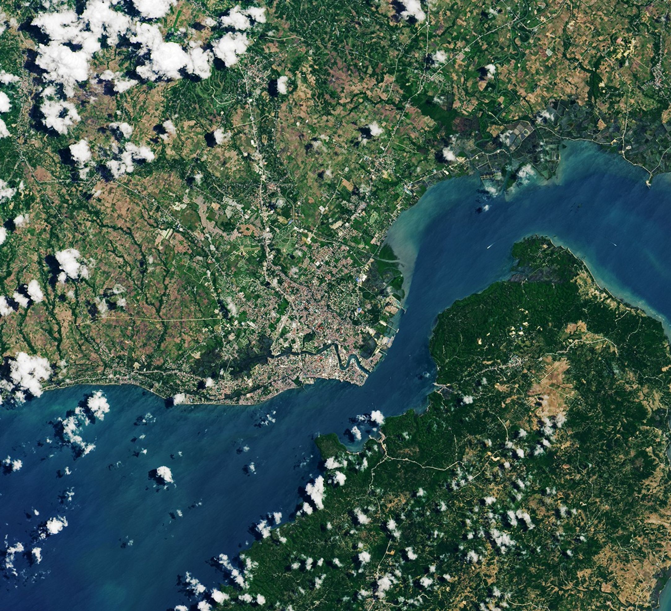
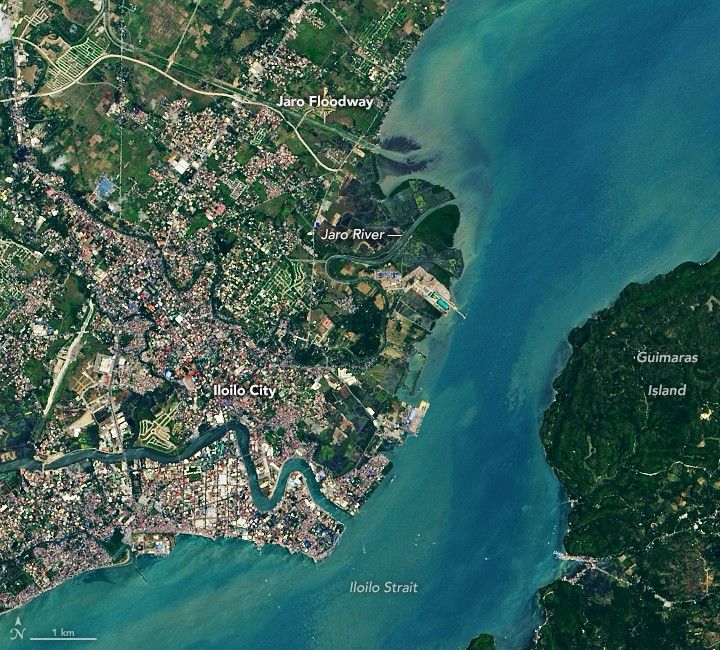
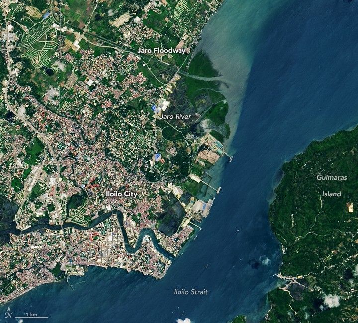
Like many port cities in the Philippines, Iloilo City is susceptible to intense flooding and massive landslides each year. In 2011, the government completed the construction of an artificial waterway—the Jaro Floodway—to help divert floodwaters away from the city and mitigate the deadly events. But the new channel also brought an unexpected surprise: a resurgence of mangrove trees.
Home to nearly half a million people, Iloilo City is a major hub for sugar exports and fishing. The Jaro River, approximately 17 kilometers (11 miles) long, runs through it. Flowing across this low, flat terrain, the Jaro rises out of its banks during heavy rain events and floods portions of the city.
The Jaro Floodway helps mitigate this flooding by diverting water from Jaro River tributaries, the Aganan and Tigum rivers. Part of the Iloilo Flood Control Project, the nearly 5-kilometer- (3-mile-) long channel was constructed to reroute the tributaries’ floodwaters and discharge them directly to the Iloilo Strait. The project included river improvements, diversion channel and dam construction, and watershed management.
Since the construction of the floodway, the city’s shoreline has noticeably shifted and grown. The images show Iloilo City and its surrounding waterways on April 1, 2013, and May 3, 2021. The images were captured by the Operational Land Imager (OLI) on Landsat 8. Note the changes at the mouth of the Jaro Floodway, including a new delta lobe and an increase in greenery.
From 2010 to 2018, the shoreline grew farther into the water, or prograded, by 1.4 kilometers (0.9 miles) due to increased sedimentation, according to a recent study. Researchers from the University of Philippines found that the condensed flow of the floodwater increased the efficiency of sediment delivery to the coast. The sediments have readily accumulated on the relatively flat and shallow seafloor at the mouth of the floodway. The wider shallow area at the floodway plain also hinders wave activity that would normally rework and remove the sediments. Another factor, according to the researchers, is a general increase in heavy rainfall events that has increased the sediment loads flowing from upstream farms and human settlements.
The expanded shoreline also created a larger intertidal zone, which provided a suitable site for mangrove forests. Mangroves are networks of hardy trees and shrubs, growing in slow-moving waters where sediments settle. The forests serve as important habitat for many marine species; they also protect shorelines from storms and flooding. Mangroves are familiar old friends to Iloilo City, as they covered around 38 hectares (94 acres) of shoreline from 1947-1988. Over the decades though, the area covered by forests decreased due to increased typhoon activity and the construction of aquaculture ponds.
After the creation of the floodway, mangrove forests grew at a rate of 4.3 hectares (11 acres) per year from 2010 to 2018. While people have planted some the mangroves in the area, the majority have appeared naturally. According to the Department of Environment and Natural Resources, most mangroves belong to the Avicennia species common to exposed coastlines.
References & Resources
- CTI Engineering International Co. Ltd Iloilo Flood Control Project (Phase I and II). Accessed May 25, 2021.
- Environmental Science of Social Change, Inc. (2011, February 1) Good governance initiatives in flood management, Iloilo City. Accessed May 25, 2021.
- Explore Iloilo (2011, August) Jaro Floodway August 2011 Updates. Accessed May 25, 2021.
- Flores, P.C.M. et al. (2020) Mangrove Forest Cover Change (1947-2018) at The River Mouth Section of The Jaro Floodway, Iloilo City, Philippines. IEEE 246-249.
- Flores, P.C.M. et al. (2020) Shoreline Change in Response to the Construction of a Flood Canal in Jaro, Iloilo City, Philippines. IEEE 134-137.
- Panay News (2020, November 21) Iloilo City puts up âforest pocketâ along floodway. Accessed May 25, 2021.
- Panay News (2019, February 12) GMA: Iloiloâs flood control âbackbone of progressâ. Accessed May 25, 2021.
- Philippine News Agency (2020, January 15) 10 Iloilo towns vulnerable to flooding, landslides identified. Accessed May 25, 2021.
- Republic of the Philippines About Iloilo. Accessed May 25, 2021.
NASA Earth Observatory images by Lauren Dauphin, using Landsat data from the U.S. Geological Survey . Story by Kasha Patel .