


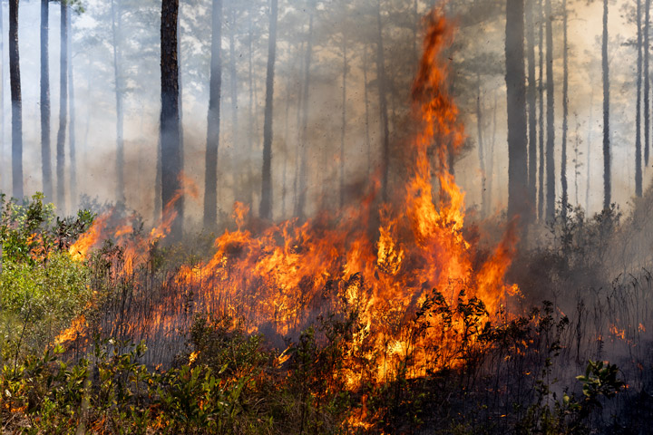
On April 14, 2025, flames ate through brush and stands of longleaf pine trees on Fort Stewart-Hunter Army Airfield in southeast Georgia, burning a total of 1,885 acres. Prescribed burns, conducted by the U.S. Department of Defense (DoD), are a routine part of the army base’s land management. However, this event unfolded as teams with NASA’s FireSense and seven DoD-funded fire research projects collected airborne, spaceborne, and ground data before, during, and after the fire, revealing intricate patterns in its progression.
The airborne observations provide more than just striking images; they are helping researchers from the U.S. Forest Service, academia, and private industry test new instruments and technology. They are also being used in combination with satellite and ground-based data to improve fire models and evaluate if the fire behaved as expected—information intended to aid future prescribed fire strategies.

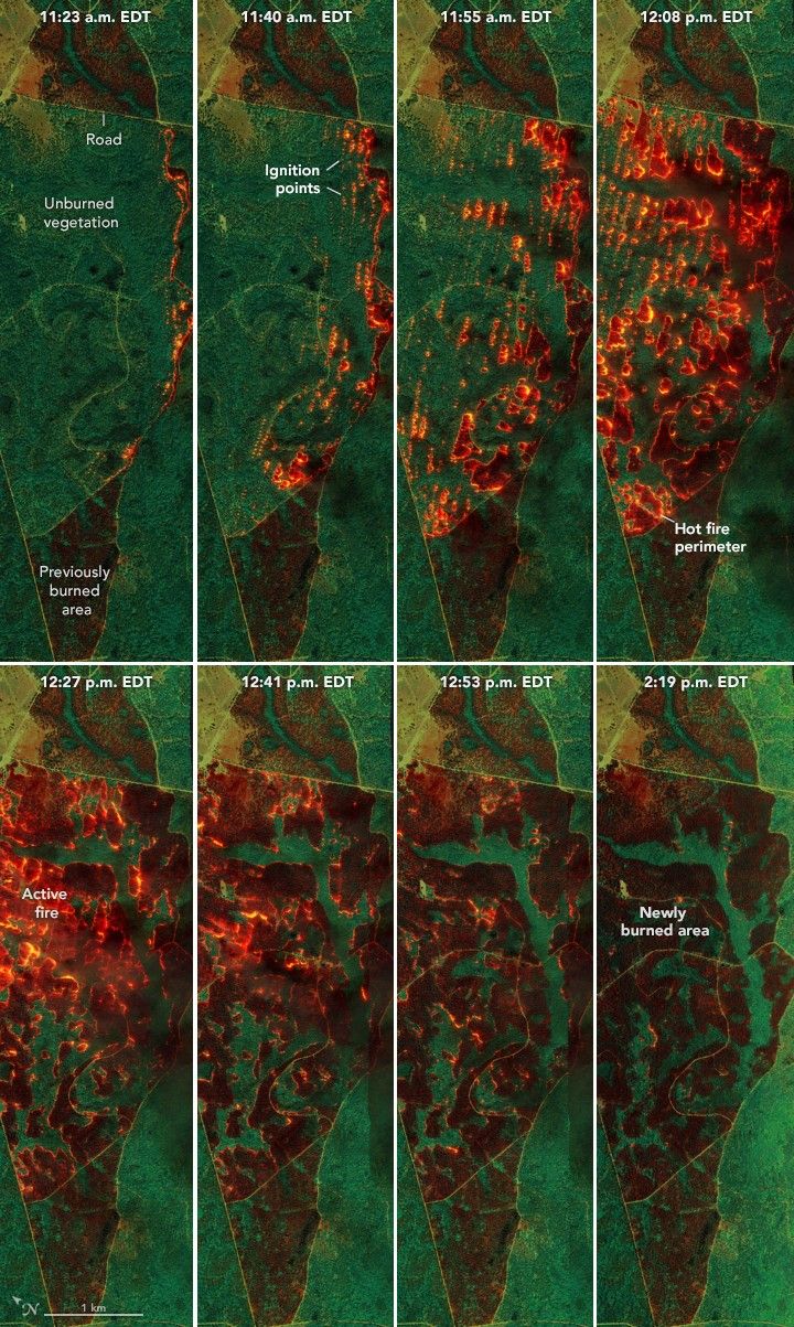
NASA’s AVIRIS-3 (Airborne Visible Infrared Imaging Spectrometer 3), mounted on a NASA-contracted Dynamic Aviation B200 King Air research plane (above), was among several airborne sensors collecting data that day. The instrument measures sunlight reflected off the ground, as well as the energy emitted from the surface, such as the light and heat from fire. The image series at the top of this page, acquired over the course of the burn on April 14, combines three infrared wavelengths (2,350, 1,200, and 1,000 nanometers) to cut through the smoke and identify the relative intensity of burning.
The sequence begins (top left) at 11:23 a.m. local time (15:23 Coordinated Universal Time), which was around the start of the burn. The remaining images show AVIRIS data that was collected over the next 3 hours during additional passes over the burn. Notice the brown areas located at the top and bottom of each scene. These are previously burned areas, which can act to help contain the fire within designated boundaries. Roads, which appear as thin, straight lines, serve a similar purpose.
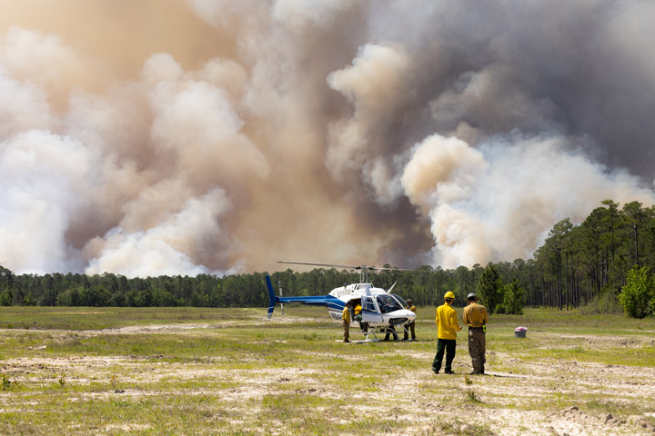
The aircraft was following a helicopter, pictured below, that dropped incendiary “ping pong balls”—small ignition devices—in a carefully coordinated pattern. Each pass of the aircraft captures the progression of the fire, from the point-source ignitions to the spreading and merging of the flaming fronts. Orange and red colors are cooler-burning areas; yellow marks the hottest zones, which become widespread in the top-right and bottom-left scenes; and bright green patches are unburned vegetation.
The final scene shows that active flaming has concluded. Hotspots and smoldering areas likely persist, but they are not obvious in this image; another AVIRIS-3 band (2,400 nanometers) better observes those phenomena. Several strips of vegetation remain unburned within the prescribed fire area. These are made up of primarily low-lying, soggy terrain with high fuel moisture, making it less likely to burn.
Prescribed burns can reduce hazardous fuels, promote ecosystem health, and maintain habitats. In the U.S. Southeast, those habitats include longleaf pine forests that support an array of species, such as red-cockaded woodpeckers, wild turkeys, and gopher tortoises. At Fort Stewart, ecosystem health and habitat maintenance occur alongside the burn’s primary motivation of reducing fuels in support of the base’s training operations and military readiness.
The DoD Strategic Environmental Research and Development Program (SERDP) joined with NASA’s FireSense campaign to provide the fire behavior and vegetation data necessary to validate observations from airborne and spaceborne sensors. Data collected at Fort Stewart and from other fires are analyzed after the burns are complete, though some airborne observations have aided fire management decisions in real time. In March 2025, for example, flights made with AVIRIS-3 supported operations in the field at wildland fires in several southeastern U.S. states and a prescribed burn in Geneva State Forest in Alabama.
Jacquelyn Shuman, a forest ecologist at NASA’s Ames Research Center and project scientist for FireSense, described AVIRIS as a comprehensive toolkit. “AVIRIS collects information on the ground prior to a fire and in real-time during a fire, providing valuable information to those on the ground,” she said. “At Fort Stewart, we’re looking at how the data can inform models and update our planning. Did the fire behave as we expected it to?”
Researchers like Ryan Wade, a research meteorologist at the University of Alabama in Huntsville and NASA’s Marshall Space Flight Center, are working to find out. Preliminary analyses of data collected in the field suggest that fuel moisture, ignition patterns, and weather conditions affected the fire as expected. Also, the fast ignition time of this burn appears to have produced a fire intense enough to modify the local weather environment. “Weather plays a huge role in impacting fire,” Wade said, “but intense fires can also feedback to impact weather.”
References & Resources
- NASA FireSense. Accessed July 15, 2025.
- NASA (2025, April) FireSense Fort Stewart Prescribed Burn Campaign. Accessed July 15, 2025.
- NASA Earth Observatory (2025, April 29) Wildfire Maps Help Firefighters in Real Time. Accessed July 15, 2025.
- NASA’s Jet Propulsion Laboratory (2025, April 23) NASA Airborne Sensor’s Wildfire Data Helps Firefighters Take Action. Accessed July 15, 2025.
- NASA’s Scientific Visualization Studio (2025, May 14) NASA FireSense (Fort Stewart-Hunter Army Airfield, Georgia). Accessed July 15, 2025.
- SERDP & ESTCP Eastern Innovation Landscape Network. Accessed July 15, 2025.
- SERDP & ESTCP (2025, July 8) SERDP & ESTCP Drive Industry Engagement for Wildland Fire Innovation. Accessed July 15, 2025.
NASA Earth Observatory images annotated by Lauren Dauphin using AVIRIS-3 data via the AVIRIS Data Portal AVIRIS Data Portal . Photos by Milan Loiacono/NASA’s Ames Research Center. Story by Kathryn Hansen. The Environment and Natural Resources Division (ENRD) Forestry Branch at Fort Stewart-Hunter Army Airfield led the burn operations, while scientists collected ground and airborne measurements. FireSense coordinated with the DoD Strategic Environmental Research and Development Program (SERDP) and DoD Environmental Security Technology Certification Program (ESTCP), U.S. Forest Service, as well as other agency, academic, and private partners to conduct simultaneous ground, airborne, and spaceborne data collection on prescribed fires at Fort Stewart-Hunter Army Airfield.


