


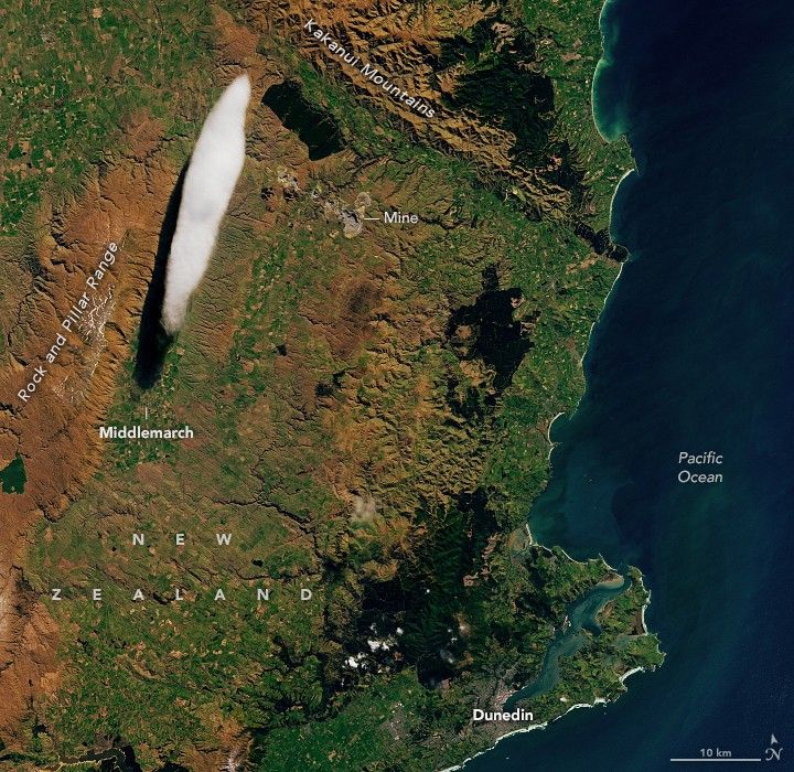
New Zealand’s stunning scenery has famously provided the backdrop for fictional worlds in fantasy films. A unique cloud that forms over the Otago region of the country’s South Island also evokes the otherworldly, while very much existing in reality.
The elongated lenticular cloud seen here, known locally as the “Taieri Pet,” is a product of the particular weather patterns and topography on the southern part of New Zealand’s South Island. The OLI (Operational Land Imager) on Landsat 8 acquired this image of the phenomenon on September 7, 2024.
Lenticular clouds form when prevailing winds encounter a topographic barrier, such as a mountain range. Wind that is forced to flow up and over the mountains creates a kind of wave in the atmosphere. Air cools at the crest of the wave, and the water vapor it contains condenses into clouds. Conversely, falling air leads to warming and evaporation.
“The Taieri Pet is a common feature found in the skies near Middlemarch, Otago,” said meteorologist John Law of New Zealand’s MetService. Here, strong winds from the northwest pour over the steep-sided, flat-topped Rock and Pillar Range, which runs almost perpendicular to those prevailing winds. “As the cloud forms on the crest of this wave, it remains almost stationary in the sky and is shaped by the strong winds blowing through it,” Law said.
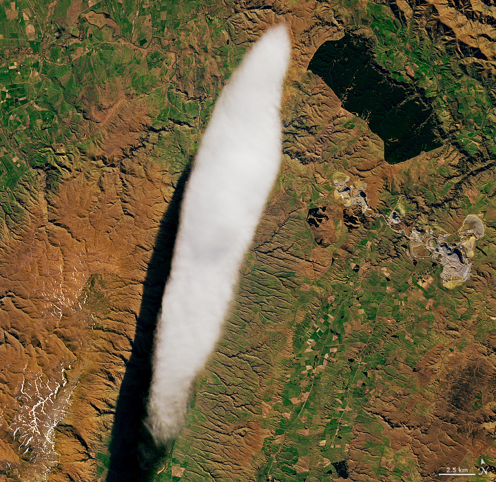
Lenticular clouds appear smooth with well-defined edges. Ground-based and airborne observers have described them as a “huge stack of pancakes” or a “pile of plates” that seem to hover in one place. But those looks can be deceiving. “The appearance of the Taieri Pet is a great indicator of strong winds high in the atmosphere,” Law said. Conditions in and around these types of clouds pose aviation hazards in the form of vertical currents, severe turbulence, and icing. In some settings, lenticulars can signal that precipitation is on the way.
References & Resources
- MetService (2010, October 18) The Foehn Wind. Accessed September 12, 2024.
- NASA Earth Observatory (2021, January 19) Curious Clouds in the Transantarctic Mountains. Accessed September 12, 2024.
- National Library of New Zealand (1951, May) Taieri Pet at Middlemarch. Accessed September 12, 2024.
- New Zealand Department of Conservation Rock and Pillar Conservation Area. Accessed September 12, 2024.
- YouStorm, via X (2024, September 8) Cigar-shaped lenticular cloud formed from uplift over the Rock and Pillar Range, Otago, New Zealand. Accessed September 12, 2024.
NASA Earth Observatory image by Lauren Dauphin, using Landsat data from the U.S. Geological Survey . Story by Lindsey Doermann .


