


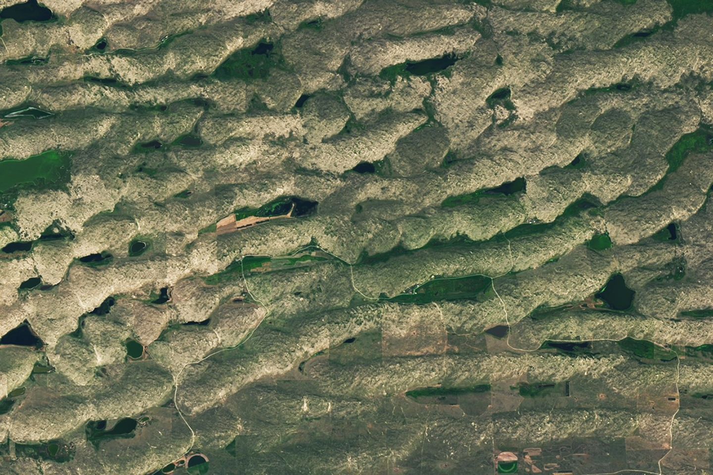


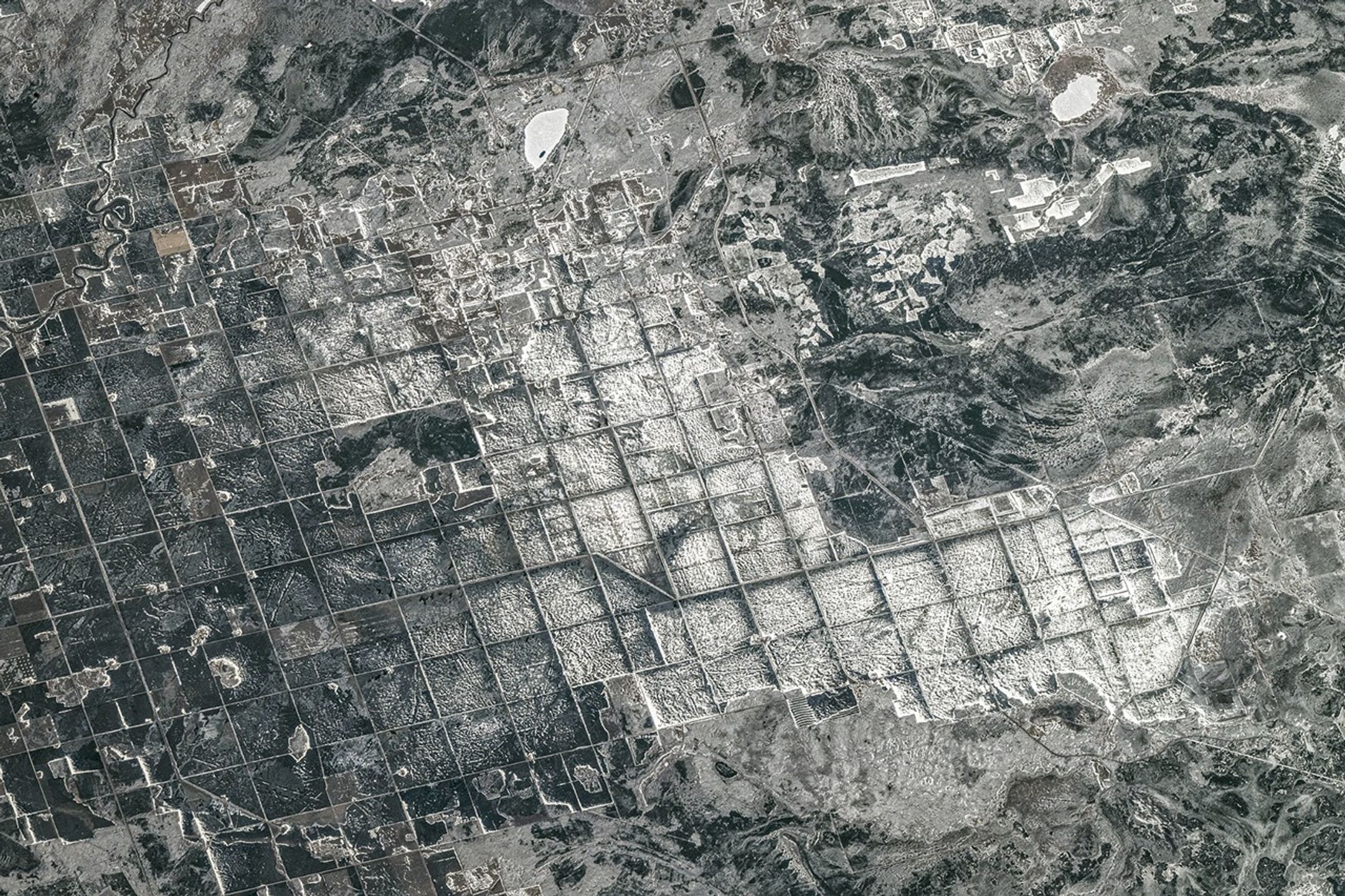
Update on May 20, 2026: This photograph taken by an astronaut on the International Space Station shows snow-covered fields in southeastern Manitoba. Congratulations to Shweta for being the first reader to name the location. Special mentions go to David B., Prathapani, and Martin. Read more about the area in our Image of the Day story, "Farming in Ancient Lake Agassiz." Thank you for your many submissions, and please read on for more from the winners!
---------------------------------------------------
The image shows the southern tip of Lake Winnipeg in Canada. I recognized the unique grid patterns of the crop fields, which I learned are used for growing wheat, barley, oats, and canola. Technical details that caught my eye: Captured by: ESA Astronaut Sophie Adenot. Camera: Nikon Z 9 with a 400mm lens. Platform: International Space Station (ISS) at an altitude of 267 miles above Ontario. Image ID: iss074e0494100 (taken on April 19, 2026). It's fascinating to see how human agriculture and natural frozen landscapes create such a geometric beauty from space!
– Shweta Vashisth at 4:12 a.m. on May 12
---------------------------------------------------
The distinctive grid pattern visible in the image is a result of the Dominion Land Survey (DLS) system. This was a method used to divide much of Western Canada into square townships and sections for settlement and agricultural development.
– David B. at 9:59 a.m. on May 12
---------------------------------------------------
The sub-freezing landscape at the southern tip of Lake Winnipeg is a flat glacial clay plain (the bed of Lake Agassiz) modified by a river delta. The extreme cold transforms this soft, water-saturated clay into a frozen, rigid surface where frost heave, ice lensing, and lake-ice scouring are the active geological forces shaping the land during the winter months.
– Prathapani Prakash at 1:08 a.m. on May 13
---------------------------------------------------
The photo shows Gull Lake at the top and frozen fields below. Below of Winnipeg Lake, in the Canadian province of Manitoba. Here's the coordinates of Gull Lake : 50°24'32.31"N 96°30'51.32"W Have a good day and thanks for all!!
– Martin at 8:12 p.m. on May 18
---------------------------------------------------
Every month, NASA Earth Observatory features a puzzling satellite image. The May 2026 puzzler appears above.
Your Challenge
Identify the location shown in this satellite image. Share what clues you see, where you think it is, and what makes this place interesting or unique to you.
How to Answer
Submit your response using this form and select “Puzzler Answer” as the topic. Please include your preferred name or alias.
You can keep it simple and just guess the location. Want to impress us? Tell us which satellite and instrument captured the image, which spectral bands were used, or point out a subtle detail about the geology or history of the area. If something catches your eye, or if this is your home or means something to you, we’d love to hear about it.
The Prize
We can’t offer prize money or a trip to space to see Earth like satellites and astronauts do. But we can offer something almost as rewarding: puzzler bragging rights.
About a week after the challenge, we’ll post the answer at the top of this page, along with a link to an Earth Observatory Image of the Day story that explains the image in more detail. We’ll recognize the first person who correctly guesses the location, and we may also highlight readers who share especially thoughtful or interesting answers. By submitting a response, you acknowledge that your comments may be edited, excerpted, and published on this page.
Until then, zoom in, look closely, and enjoy the challenge. See you at the reveal!