
1972 - 2014
Orlando, Florida: Four Decades of Development
Orlando, Florida, is reported to be the most visited destination in the United States. In 2014, more than 62 million people flocked to this centrally located city in the Sunshine State. And while the exact number of visitors fluctuates from year to year, tourism has had a marked impact on the landscape.
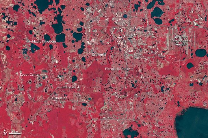
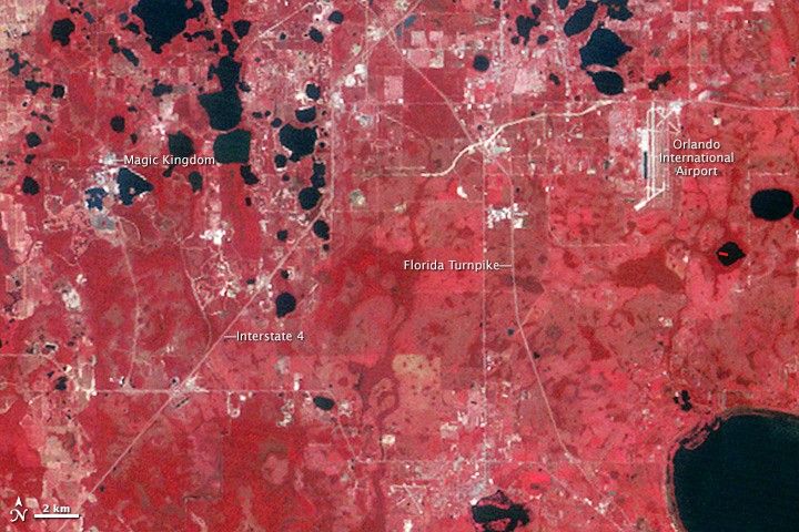
The spread of development is visible in these false-color images of greater Orlando. Acquired with the Landsat series of satellites, the scenes are shown in green, red, and near-infrared light, a combination that helps differentiate components of the landscape. Water is black, vegetation is red, and urban areas are brown to gray.
At the time that the top image was acquired (September 6, 1972), the Magic Kingdom—the first of Walt Disney World’s four theme parks—had been open for nearly a year. By the time the bottom image was acquired on May 17, 2014, Disney had opened three more theme parks. (Note that the resolution of the Landsat imaging instrument was lower at the time of the earlier image.) The Disney resort had grown to cover more than 100 square kilometers (40 square miles), about same area as the city of San Francisco.
Other theme parks also took shape, such as SeaWorld Orlando and Universal Studios. With the growth of theme parks came the growth of businesses and infrastructure to accommodate the influx of visitors. Turn on the image comparison tool to see shopping malls, hotels, and other service industries fill in the space along the major highways, as well as the paving of many secondary roads. Schools, neighborhoods, and businesses were also built to support the area’s influx of year-round and seasonal residents.
The population of the greater Orlando area (including areas beyond the scope of these images) has been growing steadily. The population of Orlando metro area in 1970 was just over 500,000 people, according to the U.S. Census Bureau. As of July 1, 2014, more than 2.3 million people were estimated to live there. According to news reports, housing developers in Orange County have struggled to keep up with demand.
Visit our newest World of Change feature to see a more detailed time series of Orlando’s development.
References & Resources
- Foglesong, R. (2003) Married to the Mouse: Walt Disney World and Orlando (Yale University Press).
- Forbes (2010, April 28) List: America’s Most-Visited Cities. Accessed July 17, 2015.
- Gizmodo (2014, April 20) Celebration, Florida: The Utopian Town That America Just Couldn’t Trust. Accessed July 17, 2015.
- NASA Earth Observatory: World of Change (2015, July 21) Development of Orlando, Florida.
- National Geographic (2007, March) Beyond Disney. Accessed July 17, 2015.
- Orlando My Way (2015, July 17) Best amusement parks list released by TripAdvisor. Accessed July 17, 2015.
- The Orlando Sentinel (2015, June 3) Universal Orlando visitation spikes, Sea World’s plunges. Accessed July 17, 2015.
- Time (2014, October 1) This Map Shows That Disney World Has Grown Like Crazy. Accessed July 17, 2015.
- United States Census Bureau (2015) Seeking the Sunshine. Accessed July 17, 2015.
- United States Census Bureau (2015) Celebration CDP, Florida. Accessed July 17, 2015.
- United States Census Bureau (2013, August) The Racial and Ethnic Composition of Local Government Employees in Large Metro Areas, 1960-2010. Accessed July 17, 2015.
- Visit Orlando (2015, April 9) Orlando Becomes First Destination to Surpass 60 Million Visitors, Sets New Record for U.S. Tourism. Accessed July 17, 2015.
- Walt Disney Parks and Resorts (2014) Walt Disney World Fact Sheet. Accessed July 17, 2015.
NASA Earth Observatory images by Jesse Allen, using Landsat data from the U.S. Geological Survey. Caption by Kathryn Hansen.