


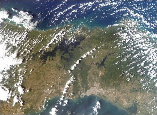
The Panama Canal is a 50-mile long engineering wonder connecting theCaribbean Sea and the Pacific Ocean. Completed by the United States in1914, it runs southeastward from Colon, through the man-made Gatun Lake,to Panama City on the Pacific side of the Isthmus of Panama. The canal,a major artery of international shipping, uses a series of massive locks,manmade lakes, and water supplied by the copious tropical rainfall ofthe region to lift and lower transiting ships a height of 85 feet overthe continental divide.
Thick rainforests border the canal, and the protected Canal Zone iseasily delineated by the dark green band of forest, which contrast thelighter green cultivated areas of Panama. The ecologically sensitiveCanal Zone supports diverse lowland rainforest that is crucial for waterbalance and erosion/siltation control around the canal. Scientistsmonitor the edges of the Canal Zone rainforest for degradation fromdevelopment.
The crew of the International Space Station acquired this image on theafternoon of January 30, 2003, using an electronic still camera with 85 mm lens. Fair-weather cumulus clouds from theCaribbean can be seen pouring southward through the natural gap in this mountain chainof Central America.
References & Resources
Astronaut photograph ISS006-E-23743 was taken with an Electronic Still Camera equipped with an 85 mm lens, and is provided by the Earth Sciences and Image Analysis Laboratory at Johnson Space Center. Additional images taken by astronauts and cosmonauts can be viewed at the NASA-JSC Gateway to Astronaut Photography of Earth.
None


