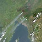


Located near the equator in central Africa, the Nyamuragira and Nyiragongo volcanoes are often obscured from satellite view by clouds. But on February 9, 2015, clear skies afforded an unobstructed view from space of two plumes venting from the volcanic duo in the Democratic Republic of the Congo.
The natural-color images above were acquired by the Operational Land Imager (OLI) on Landsat 8. The top image shows a broad view of the region, with Nyamuragira to the north and Nyiragongo to the south.
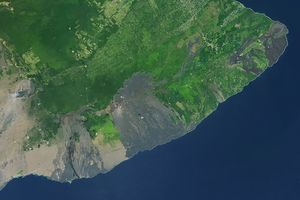
The second image shows a close-up view of Nyamuragira, Africa’s most active volcano. Nyamuragira is a shield volcano composed of old lava flows that cover about 1,500 square kilometers (580 square miles). The slopes of this broad volcano rise gradually, reaching an altitude of 3,058 meters (10,033 feet).
The volcano is topped with a small caldera with walls about 100 meters (330 feet) high. In 1938, a lava lake within the caldera drained during a large, long-lasting fissure eruption that sent lava flows all the way to Lake Kivu. Satellite observations and helicopter overflights confirmed in 2014 that the caldera again contains a small but vigorous lava lake.
The third image shows a close-up of Nyiragongo, another highly active volcano just 15 kilometers (9 miles) southeast of its northern sibling. In contrast to Nyamuragira’s relatively gentle slopes, Nyiragongo is a steep-sloped structure composed of alternating layers of solidified ash, hardened lava, and rocks ejected by previous eruptions. Its caldera also holds molten lava, which as of 2014 was the largest-known lava lake on Earth.
Occasionally, Nyiragongo spews more than just steam and volcanic gases. Eruptions of fluid lava from the volcano in 1977 and 2002 had deadly consequences for the city of Goma, which lies about 15 kilometers (9 miles) south of the volcano.
References & Resources
- Campion, R. (2014, November 7) New lava lake at Nyamuragira volcano revealed by combined ASTER and OMI SO2 measurements. Geophysical Research Letters, 41 (21), 7485-7492.
- NASA Earth Observatory (2014, June 30) Nyamuragira Volcano Erupts. Accessed February 13, 2015.
- NASA Earth Observatory (2007, May 8) Nyiragongo Vents Steam. Accessed February 13, 2015.
- NASA Earth Observatory (2007, December 10) Nyamuragira and Nyiragongo. Accessed February 13, 2015.
- Smithsonian Institution Global Volcanism Program (2014) Nyiragongo. Accessed February 13, 2015.
- Smithsonian Institution Global Volcanism Program (2014) Nyamuragira. Accessed February 13, 2015.
NASA Earth Observatory images by Jesse Allen, using Landsat data from the U.S. Geological Survey.