July 4, 2010
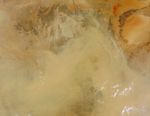
Dust blew over the borders of Niger, Algeria, and Mali on July 4, 2010. The Moderate Resolution Imaging Spectroradiometer (MODIS) on NASA’s Terra satellite captured this natural-color image the same day. The dust differs from the land underneath primarily in the plume’s uniform color. Whereas the Sahara land surface varies from beige to brick, the dust plume is uniformly tan.
Source points for the plume are not obvious in this image, but at least some of the dust may have arisen from sand seas stretching over much of eastern Niger. Sand seas also sprawl over most of Mali and much of Algeria. Over southwestern Libya, skies are clear.
References & Resources
NASA image courtesy Jeff Schmaltz, MODIS Rapid Response Team at NASA GSFC. Caption by Michon Scott.