


Torrential rain in the Pacific Northwest spurred deadly floods and mudslides that have damaged infrastructure and isolated communities in Canada and the United States. Much of the rain fell from November 13-15, 2021, the product of a potent atmospheric river that took aim at the region and added more moisture to already saturated soils.
The map above depicts a satellite-based estimate of rainfall over the 24-hour period on November 14—a day that broke numerous records. The darkest reds reflect the highest rainfall amounts, with some places receiving as much as 10 centimeters (4 inches) or more during this period (the top of our scale). The data are remotely sensed estimates that come from the Integrated Multi-Satellite Retrievals for GPM (IMERG), a product of the Global Precipitation Measurement (GPM) satellite mission. Local rainfall amounts can be significantly higher when measured from the ground.
On November 14, the airport gauge in Hope, British Columbia, collected 17.4 centimeters (6.8 inches) of rain. Vancouver measured 5.3 centimeters (2 inches) that day. Both cities set new daily records. The airport in Bellingham, Washington, reported 7 centimeters (2.8 inches), the fifth-wettest day on record. Almost 2 more inches fell the following day, breaking the city’s two-day rainfall record.
The rainstorm was the latest in a parade of storm systems that have walloped the Pacific Northwest in recent months. Parts of the Pacific Northwest have endured an extraordinarily wet autumn, inching toward the seasonal record. With soils already saturated, the torrential rain from the latest atmospheric river posed an even higher risk for flooding and mudslides.
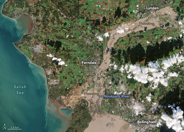
Flooding along Washington’s Nooksack River is visible in this natural-color image, acquired on November 16, 2021, by the European Space Agency’s Copernicus Sentinel-2 mission. On this day, the river crested at 7.24 meters (23.76 feet), short of the highest crest on record (31.23 feet in February 1951) but still higher than the river has risen in decades. From Lynden to Ferndale to the mouth of the river at Bellingham Bay, floodwaters inundated neighborhoods, businesses, and farmland. In Whatcom County, 500 people evacuated their homes.
Devastation from the rain extended well north of this image. On November 17, government officials declared a state of emergency in British Columbia. With rail lines and roads shut down, the Port of Vancouver was essentially cut off from inland areas, unable to move goods in or out. In Hope, more than 1,000 people were stranded when roads exiting the town were blocked by mudslides. Elsewhere across the Fraser Valley, thousands of animals perished as hundreds of farms were inundated with floodwater.
References & Resources
- AP News (2021, November 17) Northwest Storm: âDevastatingâ flood damage, 1 dead in BC. Accessed November 18, 2021.
- Bloomberg (2021, November 17) Vancouver Is Cut Off by Road, Rail After âExtraordinaryâ Storms. Accessed November 18, 2021.
- CBC News (2021, November 17) Historic flooding in southern B.C., by the numbers. Accessed November 18, 2021.
- CBC News (2021, November 17) Thousands of animals have died on flooded B.C. farms in âagricultural disasterâ. Accessed November 18, 2021.
- CBC News (2021, November 15) Coquihalla Highway and sections of Hwy 1 closed due to major flood damage. Accessed November 18, 2021.
- Cliff Mass Weather Blog (2021, November 15) Extreme Precipitation and Flooding in Whatcom County. Accessed November 18, 2021.
- European Space Agency (2021, November 18) Washington state flooding. Accessed November 18, 2021.
- The Guardian (2021, November 18) How bad is the Pacific north-west flooding and what caused it? Accessed November 18, 2021.
- King 5 News (2021, November 16) Heavy rain brings near-historic flooding to Skagit River near Mount Vernon. Accessed November 18, 2021.
- The New York Times (2021, November 16) Womanâs Body Recovered From Mudslide in British Columbia as Evacuations Continue. Accessed November 18, 2021.
- Reuters (2021, November 17) Canada floods cut rail link to Vancouver port; one dead. Accessed November 18, 2021.
- The Washington Post (2021, November 12) Atmospheric river is drenching Pacific Northwest as waterlogged pattern continues. Accessed November 18, 2021.
NASA Earth Observatory images by Lauren Dauphin and Joshua Stevens, using IMERG data from the Global Precipitation Mission (GPM) at NASA/GSFC and modified Copernicus Sentinel data (2021) processed by the European Space Agency. Story by Kathryn Hansen .


