


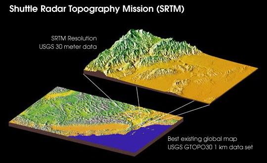
The primary objective of the Shuttle Radar Topography Mission is to acquire a high-resolution topographic map of the Earth's land mass (between 60°N and 56°S) and to test new technologies for deployment of large rigid structures and measurement of their distortions to extremely high precision.
The Shuttle Radar Topography Mission represents a breakthrough in the science of remote-sensing and will produce topographic maps of Earth 30 times as precise as the best global maps in use today. The information will be used to attempt to produce one of the most comprehensive and accurate maps of Earth ever assembled.
For more information, see the STS 99 Press Kit
or the Shuttle Radar Topogrpahy Mission homepage
References & Resources
Image by NASA/JPL/NIMA
None


