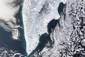


To the Inukitut-speaking peoples of the Canadian Arctic, northern Baffin Island is Sirmilik, “the place of the glaciers.” When Canada established the area as a National Park in 2001, they gave it the same name. This natural-color image of the park was captured by the Moderate Resolution Imaging Spectroradiometer (MODIS) on NASA’s Aqua satellite on October 2, 2008.
The park has three main land sections: Borden Peninsula, Bylot Island, and the terrain around Oliver Sound. Borden Peninsula is a plateau that is crisscrossed by several broad river valleys. One of these valleys in the eastern part of the peninsula and several of its tributary canyons were free of snow on this date in early fall. Bylot Island is extremely rugged, with steep mountains carved by glaciers and encased by ice fields. The steep topography is revealed by the sharply pointed shadows that stand out against the bright white snow. Oliver Sound is lined with scenic fjords, which were ice-free when this image was captured.
Sirmilik National Park has diverse geology, including evidence of scouring by the massive Laurentide Ice Sheet that covered huge parts of North America at the end of the last ice age. On Borden Peninsula, wind and water have sculpted sandstone into towers and spires known as hoodoos, reminiscent of the American Southwest. The park may seem like an icebox, but it isn’t a lifeless landscape. Dozens of species of sea birds have nesting colonies in the park, and the waters are home to narwhal whales and polar bears, among many animals. In the summer, snow retreats at low elevations around the coasts and in sheltered valleys, and Arctic wildflowers bloom.
References & Resources
- References
- Parks Canada. (n.d.) Sirmilik National Park. Accessed October 9, 2008.
NASA image by Jeff Schmaltz, MODIS Rapid Response Team. Caption by Rebecca Lindsey.