December 14, 2017
In Southern California, wildfires continue to burn.
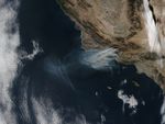
On December 14, 2017, the Visible Infrared Imaging Radiometer Suite (VIIRS) (VIIRS) on the Suomi NPP satellite acquired a natural-color image of smoke billowing from the Thomas Fire in Ventura and Santa Barbara counties.
By December 15, the fire had charred 252,500 acres (102,200 hectares or 400 square miles). That made it the fourth largest fire in California history.
References & Resources
- Cal Fire (2017, December 15) Thomas Fire. Accessed December 15, 2017.
- Los Angeles Times (2017, December 15) Thomas fire rages amid longest red flag warning on record. Accessed December 15, 2017.
NASA image by Jeff Schmaltz, LANCE/EOSDIS Rapid Response. Caption by Adam Voiland.