
For much of March and April, fires have dotted the Central American landscape, blanketing the region with smoke. (See Fires in Mexico and Central America.) In addition to smoke, the fires have released large amounts of carbon monoxide into the atmosphere, which have been detected by the Measurements of Pollution in the Troposphere (MOPITT) radiometer on NASA’s Terra satellite.
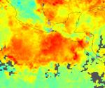
The false-color image above shows the average number of carbon monoxide molecules in the lower atmosphere between April 10 and April 20, 2005. If you were to squash a column of the atmosphere into a flat square centimeter, this measurement would reveal how many molecules of carbon monoxide filled that area. Broad strokes of red and yellow reveal high levels of carbon monoxide over all of Central America. Shades of light and dark blue that represent low carbon monoxide values are entirely missing, replaced with the aquamarine of intermediate values to show the lowest levels of carbon monoxide. Carbon monoxide is a good tracer of pollution since it is produced as a by-product of the combustion associated with wildfires and agricultural fires.
References & Resources
NASA image created by Jesse Allen, Earth Observatory, using data provided by the NCAR and University of Toronto MOPITT Teams