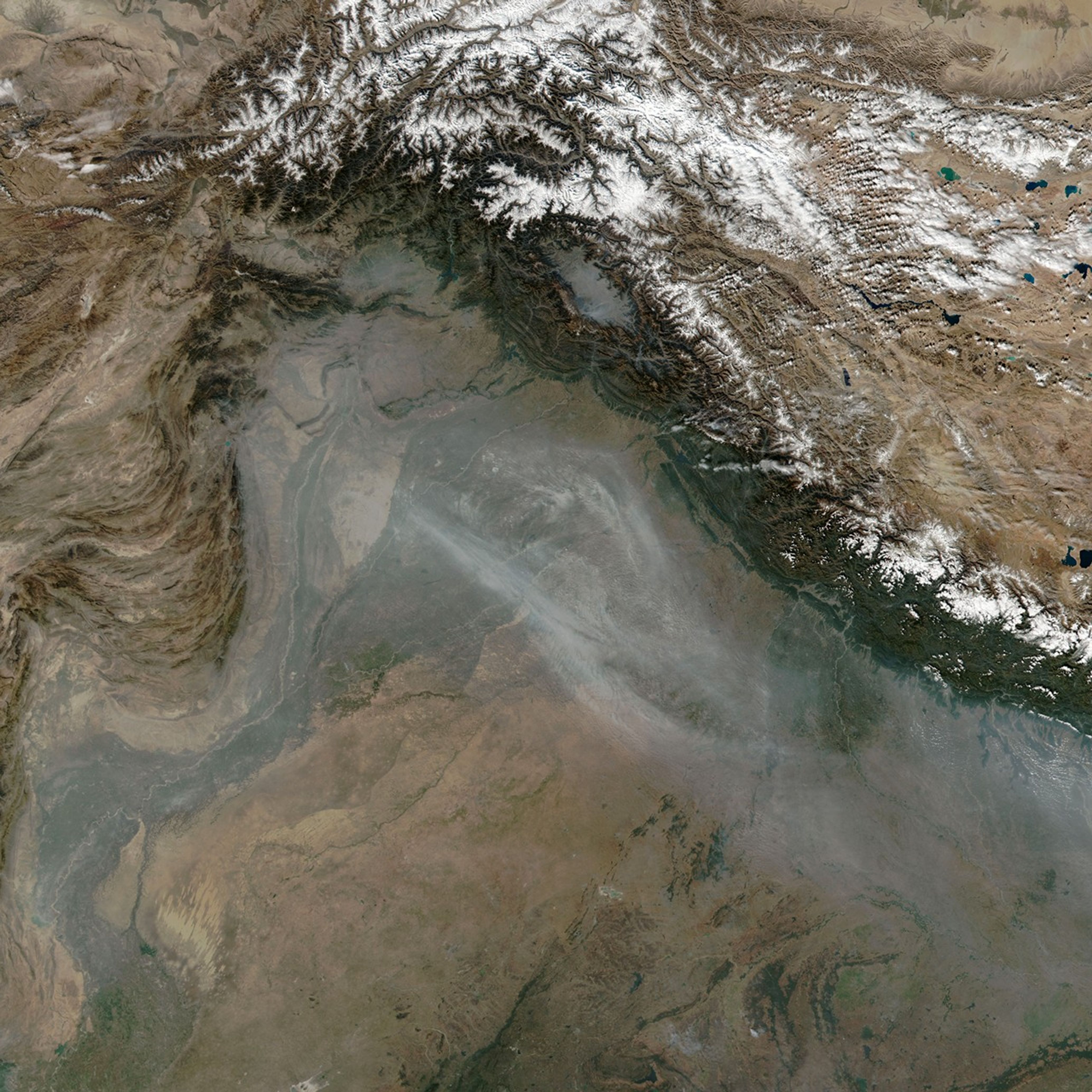


Every November, satellites detect large numbers of small smoke plumes and heightened fire activity in northern India and Pakistan as farmers burn off excess straw after the rice harvest. Many farmers, particularly in the Punjab region, use fire as a fast, inexpensive way to clean up fields before planting winter wheat crops. However, the influx of smoke to the densely populated Indo-Gangetic Plain often contributes to a sharp deterioration of air quality in October and November.
Levels of air pollution soared during the last week of October and first week of November in 2024 as weather patterns kept air bottled up in the Indo-Gangetic Plain. On November 3, 2024, the VIIRS (Visible Infrared Imaging Radiometer Suite) on the Suomi NPP satellite acquired this natural-color image of plumes of smoke streaming from large numbers of small fires burning in Pakistan and India.
Air quality sensors in Lahore, Pakistan, recorded concentrations of fine particulate matter (PM2.5) at hazardous levels—above 300 on the air quality index (AQI)—on several days in October and November, according to data posted by AirNow. As pollution levels rose, authorities in Pakistan announced school closures, partial lockdowns, and halts in construction in a bid to limit the health impacts, according to news reports.
Smoke from crop fires is not the only contributor to the hazy skies, explained Pawan Gupta, a lead scientist for AERONET, a NASA-sponsored network of ground-based sensors that measures the concentration of aerosols at hundreds of locations around the world. Influxes of dust sometimes arrive from the Thar Desert to the west. An array of other human-caused sources of air pollution in cities, including motor vehicle emissions, industrial and construction activity, fireworks, and fires for heating and cooking, also produce particulate matter and other pollutants, Gupta added.
Geography and weather can exacerbate the region’s poor air quality. Temperature inversions are common in November and December as cold air rolls off the Tibetan Plateau and mixes with smoky air from the Indo-Gangetic Plain. An inversion can function like a lid, with warm air trapping pollutants near the surface. The low-hanging haze becomes hemmed in between the Himalayas to the north and the Vindhya Range to the south.
Pollution levels in Lahore typically peak in late November and December, “so this is just beginning,” Gupta said. “The worst pollution days are probably still ahead of us.”
Hiren Jethva, a senior research scientist at NASA’s Goddard Space Flight Center and Morgan State University, uses the Normalized Difference Vegetation Index (NDVI)—a measure of the land’s “greenness”—to anticipate fire activity in the region each year. Based on the NDVI data, he expects that NASA’s Aqua satellite will detect between 15,500 and 18,500 fires in 2024—higher than most years since 2002 but lower than 2016 and 2021, years with especially bountiful rice crops.
References & Resources
- Associated Press (2024, November 4) Pakistan shuts primary schools for a week in Lahore due to dangerous air quality. Accessed November 4, 2024.
- Dawn (2024, November 3) Lahore’s AQI touches unprecedented level. Accessed November 4, 2024.
- Dawn (2024, November 3) Govt declares ‘smog calamity’ across Punjab. Accessed November 4, 2024.
- Jethva, H. via X (2024, October 1) Post-monsoon seasonal fire prediction (Oct+Nov) for 2024 over NW India has arrived. Accessed November 4, 2024.
- Jethva, H. et al., (2019) Connecting Crop Productivity, Residue Fires, and Air Quality over Northern India. Scientific Reports, 9, 16594.
- Nature (2024, October 30) A thaw in scientific relations could help clear the air in India and Pakistan. Accessed November 4, 2024.
- NASA Earthdata (2024) Air Quality. Accessed November 4, 2024.
- NASA Earth Observatory (2014, November 14) Seasons of Indian Air Quality. Accessed November 4, 2024.
- NASA (2024, September 19) Ask NASA ARSET: Remote Sensing Observations for Air Quality Applications. Accessed November 4, 2024.
- NASA (2024, September 20) NASA Data Helps Protect US Embassy Staff from Polluted Air. Accessed November 4, 2024.
- U.S. Department of State (2023, August 1) Helping Our Personnel Breathe Easier: Partnering With NASA to Expand Reliable Air Quality Data. Accessed November 4, 2024.
- World Air Quality Historical Database (2024) World Air Quality Historical Database: Lahore US Embassy.Past 67 months daily average AQI. Accessed November 4, 2024.
NASA Earth Observatory image by Michala Garrison, using VIIRS data from NASA EOSDIS LANCE , GIBS/Worldview , and the Suomi National Polar-orbiting Partnership . Story by Adam Voiland .