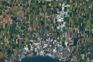
June 16, 2000-June 26, 2024
Spotting Disruptions to Earth’s Vegetation
Nestled between the Amazon and the coastal Atlantic Forest, the Brazilian Cerrado is home to thousands of species of birds and mammals, including the endangered jaguar, maned wolf, and Cerrado fox. Over the past few decades, vast swaths of the biologically rich grasslands and savanna have been converted into farms.
Compared to forests, some of the planet’s other ecosystems have seen fewer protections and less consistent monitoring. Now, using NASA data and technology, researchers can track changes in vegetation around the planet, from forested landscapes in Canada to grasslands and savannas like the Brazilian Cerrado.
The dataset—known as the OPERA Land Surface Disturbance Alert, or DIST-ALERT—uses Harmonized Landsat and Sentinel-2 (HLS) satellite data that is updated every two to four days, allowing researchers and stakeholders to monitor vegetation changes across the globe in near-real time. It was developed by the OPERA (Observational Products for End-Users from Remote Sensing Analysis) project at NASA’s Jet Propulsion Laboratory, in collaboration with the University of Maryland, for mapping vegetation cover and loss globally at a spatial resolution of 30 meters.
“This new global dataset makes it possible to monitor vegetation disturbances and deforestation events as they happen anywhere in the world,” said James MacCarthy, a research associate at World Resources Institute (WRI).
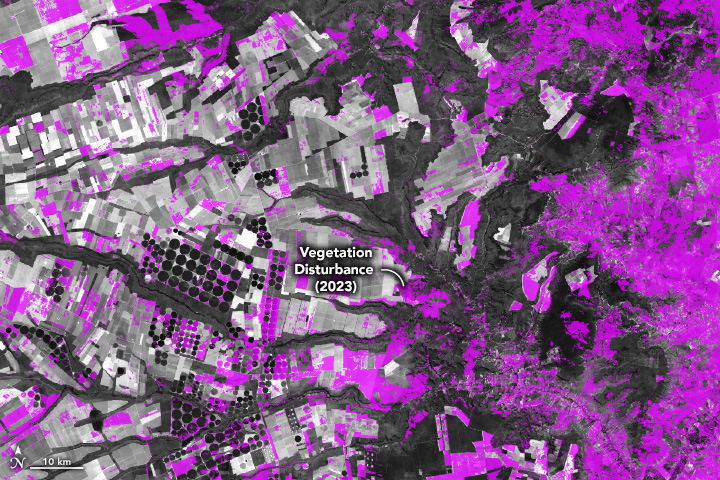
The images above show changes in land use in western Bahia, part of the Brazilian Cerrado, which is a hotspot for agricultural expansion. Between 2000 (left) and 2024 (right), some of the grasslands and scattered trees and shrubs of the Cerrado have been turned into farms that grow soybeans and cotton. Circular center-pivot irrigation systems and rectangular farms are more prevalent in the 2024 image.
The map below shows an annual summary of disturbance alerts for the same region in 2023 (shown in purple). Data for the map were provided by the University of Maryland.
MacCarthy and colleagues at WRI have made the data accessible via Global Forest Watch (GFW), an online platform that provides alerts for potential tree cover loss. Previously, GFW has been used to monitor changes in dense tropical forests. The new OPERA data provide alerts for vegetation in all ecosystems, including forests outside the tropics.
For example, the map below shows vegetation disturbance alerts in Canada during 2023. Over the course of the year’s fire season, which started early and ended late, blazes burned an estimated 18.4 million hectares—an area roughly the size of North Dakota. On average, just 2.5 million hectares burn in Canada each year. Researchers at the Land & Carbon Lab, an applied research lab convened by the Bezos Earth Fund and WRI, are developing a method to classify vegetation disturbances so that in the future, stakeholders can assess changes from different drivers, such as fires, mining, urban development, or agricultural expansion.

The OPERA alerts were also used by the U.S. Geological Survey’s SilvaCarbon program in their technical trainings to assist governments and decision-makers in monitoring forests and mitigating carbon emissions from vegetation change.
“The OPERA disturbance alerts detect forest change across more area and detect them faster than previous systems,” said Sylvia Wilson, a forester and remote sensing scientist with SilvaCarbon. Wilson noted that the more frequent revisit time of the Harmonized Landsat Sentinel-2 data, compared to Landsat alone, will be instrumental in timely forest monitoring.
References & Resources
- Damasco, G., et al. (2018) The Cerrado Biome: A Forgotten Biodiversity Hotspot. Frontiers for Young Minds, 6(22).
- Global Forest Watch (2025) Near-Real-Time Disturbance Alerts for All Vegetation Globally are Now Available on GFW. Accessed March 3, 2025.
- Land and Carbon Lab (2024, December 11) New Data Provides First Global Annual Picture of Cultivated and Natural Grasslands. Accessed March 3, 2025.
- NASA Earth Observatory (2018, September 9) Converting Savannahs into Soybeans. Accessed March 3, 2025.
- NASA Earth Observatory (2015, February 27) Soybeans in the Brazilian Cerrado. Accessed March 3, 2025.
- NASA Earth Observatory (2015, November 26) A Slice of Iowa in Brazil. Accessed March 3, 2025.
- Rodrigues, A. A., et al. (2022) Cerrado deforestation threatens regional climate and water availability for agriculture and ecosystems. Global Change Biology, 28(22), 6807-6822.
NASA Earth Observatory images by Wanmei Liang , using Landsat data from the U.S. Geological Survey and OPERA data courtesy of Zhen Song at University of Maryland Global Land Analysis and Discovery (GLAD) laboratory . Data are available from the Land Processes Distributed Active Archive Center. Story by Emily Cassidy.