


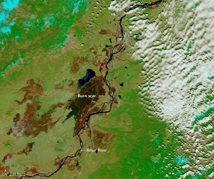

As soon as the snow melts in springtime, widespread fires typically emerge in far northeastern Russia. On May 3, 2019, the Moderate Resolution Imaging Spectroradiometer (MODIS) on NASA’s Terra satellite acquired this false-color image of a large burn scar along the Amur River in Russia’s Khabarovsk region. The image was composed using visible and infrared light (bands 7-2-1), which makes it easier to distinguish burned areas.
The Amur River Valley is a mosaic of farmland, forests, shrubs, and grasslands. It is known for being a productive agricultural region, and most of these fires were probably triggered by farmers burning off old plant debris to prepare their fields for a new crop. Some of the fires may have begun on farmland, but then escaped control and grew larger as they moved into nearby wildlands.
The large burn scar near the center of the image emerged west of the town of Naykhin on April 28, 2019, and then spread rapidly north through swampy grasslands near Lake Bolon. Separate fires that burned within the past few weeks left the scars to the north, west, and south.
The fire near Naykhin caught the attention of atmospheric scientists for producing what was likely the first pyrocumulus of the year in the Northern Hemisphere. Pyrocumulus clouds—sometimes called “fire clouds”—are tall, cauliflower-shaped, and appear as opaque white patches bubbling up from darker smoke in satellite images. Fires that produce pycumulus clouds tend to spread smoke much higher and farther than those that do not.
In order for scientists to classify a cloud as pyrocumulus, cloud top temperatures observed by satellites must be -40°C (-40°F) or cooler. According to University of Wisconsin meteorologist Scott Bachmeier, this cloud passed that threshold at 03:10 Universal Time, a few hours after the Operational Land Imager (OLI) on Landsat 8 acquired the natural-color shown image above. At that time, low-lying gray smoke streamed from an actively burning fire front as the beginning stages of the pyrocumulus cloud billowed up over the fire.
References & Resources
- NASA Earth Observatory (2019, August 9) Smoke Plumes Tower Over California.
- NASA Earth Observatory (2013, May 1) Smoke Burning Fields in Eastern Russia.
- University of Wisconsin CIMSS (2019, April 30 ) PyroCb in Russia. Accessed May 3, 2019.
NASA Earth Observatory images by Lauren Dauphin, using MODIS data from NASA EOSDIS/LANCE and GIBS/Worldview and using Landsat data from the U.S. Geological Survey. Story by Adam Voiland.


