


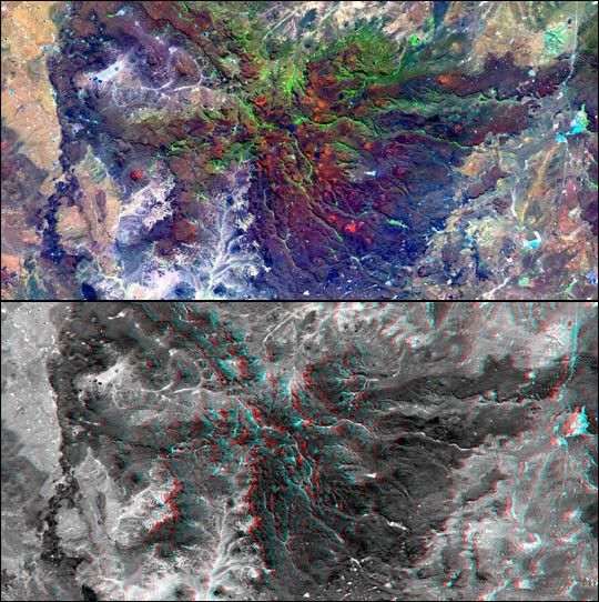
This view of northern Patagonia, at Los Menucos, Argentina showsremnants of relatively young volcanoes built upon an eroded plain ofmuch older and contorted volcanic, granitic, and sedimentary rocks. Thelarge, dark 'butterfly' pattern is a single volcano that has been deeplyeroded. Large holes on the volcano's flanks indicate that they may havecollapsed soon after eruption, as fluid molten rock drained out fromunder its cooled and solidified outer shell.
The color image (top) is derived from Landsat 7 data. Bands 1 (blue), 4(near infrared), and 7 (shortwave infrared) are shown in blue, green andred, respectively.
The anaglyph (bottom) was generated by first draping a Landsat 7Enhanced Thematic Mapper + image over a topographic map from the Shuttle Radar Topography Mission,then producing the two differing perspectives, one for each eye. Whenviewed through special glasses, the result is a vertically exaggeratedview of the Earth's surface in its full three dimensions. Anaglyphglasses cover the left eye with a red filter and the right eye with ablue filter.
Landsat satellites have provided visible light and infrared images ofthe Earth continuously since 1972. SRTM topographic data match the30-meter (99-foot) spatial resolution of most Landsat images and providea valuable complement for studying the historic and growing Landsat dataarchive. The Landsat 7 Thematic Mapper image used here was provided tothe SRTM project by the United States Geological Survey, Earth ResourcesObservation Systems (EROS) Data Center, Sioux Falls, South Dakota.
Location: 41 deg. South lat., 69 deg. West lon.
Orientation: North toward upper left
Image Data: Landsat 7 ETM+ band 4
Date Acquired: February 19, 2000 (SRTM), January 22, 2000 (Landsat)
Full resolution versions of thecolorand anaglyph imagesare available from NASA’s Planetary Photojournal.
For more information, visit:
the Shuttle Radar Topography Mission home page
and the Landsat 7 home page.
References & Resources
Images: NASA/JPL/NIMA
None


