A tornado-like storm that, according to eyewitness reports, flipped a sport utility vehicle in Sunset Beach and lifted boats out of the water along the Pacific Coast Highway was just part of the excitement in California on January 19, 2010. Forecasters warned that residents were in for several days of severe storms that would bring high winds and heavy rains.
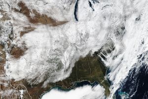
The Geostationary Operational Environmental Satellite (GOES)—built and launched by NASA, operated by the National Oceanic and Atmospheric Administration—captured a series of images of the storm activity between January 19 and 21, 2010. This image is a GOES-MODIS composite from January 20. The GOES satellite’s vantage point is over the Pacific Ocean, west of the California coast, and the image captures an apostrophe-shaped cloud bank over the coast. Animations (see links above) show successive waves of storm clouds breaking over California between January 19 and 21, 2010.
On January 19, the National Weather Service reported rain totals of 1.10 inches (2.79 centimeters) at Fullerton Airport, 1.38 inches (3.51 centimeters) at Modjeska Canyon, and 1.15 inches (2.92 centimeters) at Palomar Mountain. Heavy rains continued over the next two days. Thunderstorms knocked out power in Northern and Southern California, and flooded streets in the Los Angeles area. Authorities ordered hundreds of residents of the Los Angeles foothills to evacuate ahead of potential mudslides from areas devastated by the Station Fire, which had scorched the area months earlier. As of January 21, forecasters were warning Californians to brace for yet another storm.
References & Resources
- Gorman, S., Whitcomb, D. (2010, January 20). UPDATE 2-Heavy California storms force hundreds to flee. Reuters. Accessed January 21, 2010.
- Hecht, P. (2010, January 20). Storms keep hammering Northern California. The Sacramento Bee. Accessed January 21, 2010.
- L.A. Now. (2010, January 19). L.A. coast slammed by tornado-like storm that flips car, floods streets, strands motorists. Los Angeles Times. Accessed January 21, 2010.
- L.A. Now. (2010, January 21). As another powerful storm moves in, Southern California braces for heavy rains, mud flows and power outages. Los Angeles Times. Accessed January 21, 2010.
- National Weather Service Forecast Office, San Diego, California. Rainfall totals, January 19, 2010. Accessed January 21, 2010.
Image from the NASA-NOAA GOES Project Science Office, with animation created by Jesse Allen. Caption by Michon Scott.


