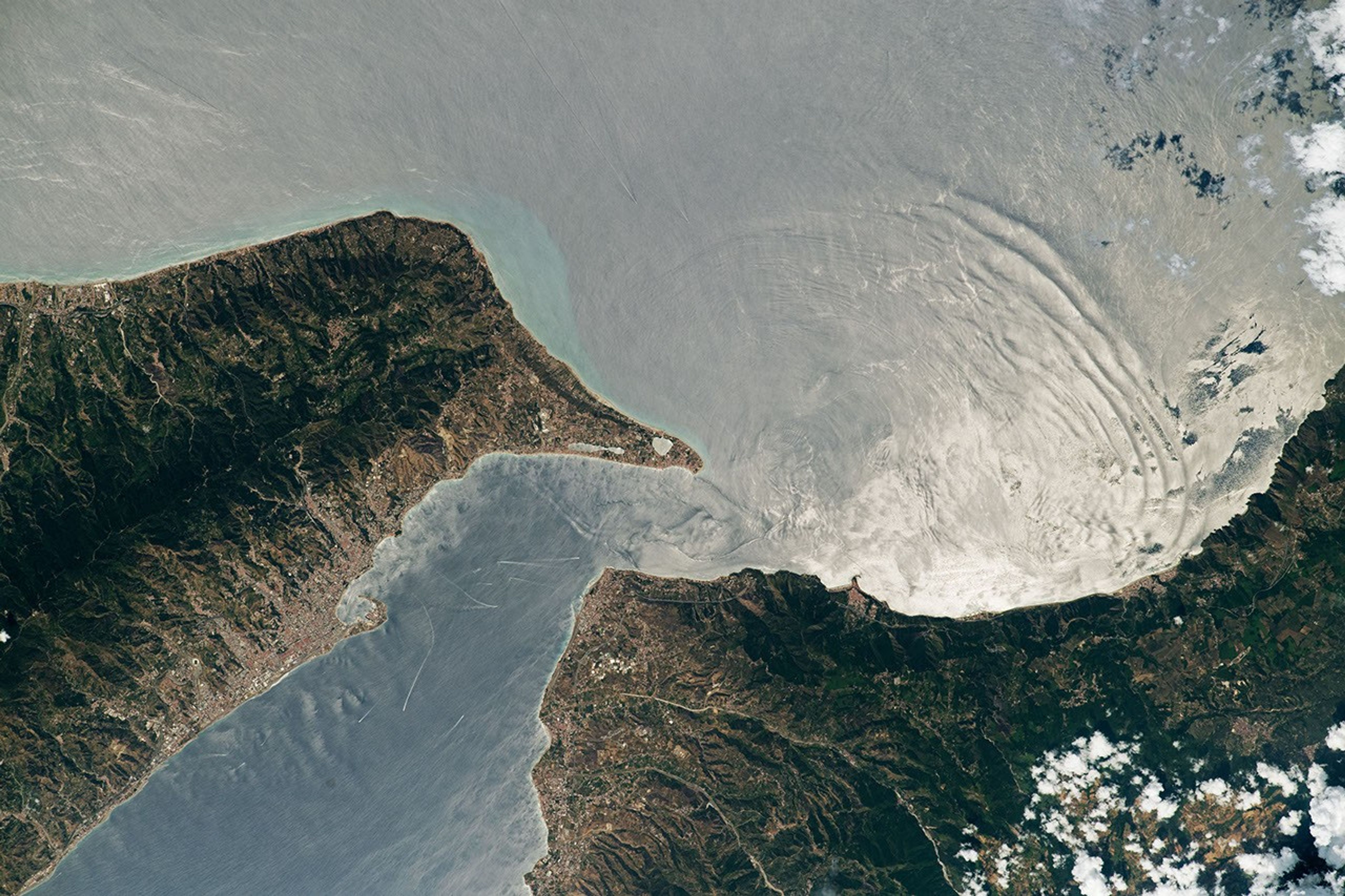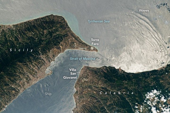
While orbiting over the Ionian Sea, an astronaut onboard the International Space Station (ISS) photographed the Strait of Messina (Messina Strait), a channel in the Mediterranean Sea that separates Sicily and Calabria. Extending about 32 kilometers (20 miles) in length, the Strait of Messina joins the Tyrrhenian Sea to the north and the Ionian Sea to the south. At its broadest point between Capo d’Alì and Punta Pellaro (out of frame to the south), the channel is about 16 kilometers (10 miles) wide and has an approximate depth of 250 meters (820 feet).
Waves that follow the tide from west to east are visible in the right half of the photo. These are caused by internal waves, a process where stratified water layers of changing density and increasing depth horizontally propagate beneath the water surface. The waves are illuminated by sunglint—an optical phenomenon that occurs when sunlight is directly reflected off the water and into a satellite’s sensor, or in this case, the astronaut’s camera.
Alternating currents, relatively low water temperature, and high levels of phosphorus and nitrogen contribute to the region’s aquatic biodiversity. The strait hosts several deep-sea fish species such as Sloane’s viperfish (a predatory dragonfish) as well as commercially valuable fish like yellowtail and snapper. On the left side of the image, thin, white lines are likely ship wakes, some of which may belong to fishing boats.
Large water mammals like dolphins and whales have been spotted in the strait. The waters also support populations of black coral (Errina aspera)—the only species of this coral family found in the Mediterranean Sea—and gold coral. In addition to the abundance of marine life, the strait is part of a major migratory route for birds. It is regularly visited by honey buzzards, Eleonora’s falcon, and long-legged buzzards.
References & Resources
Astronaut photograph ISS067-E-132335 was acquired on January 1, 2022, with a Nikon D5 digital camera using a focal length of 70 millimeters. It is provided by the ISS Crew Earth Observations Facility and the Earth Science and Remote Sensing Unit, Johnson Space Center. The image was taken by a member of the Expedition 67 crew. The image has been cropped and enhanced to improve contrast, and lens artifacts have been removed. The International Space Station Program supports the laboratory as part of the ISS National Lab to help astronauts take pictures of Earth that will be of the greatest value to scientists and the public, and to make those images freely available on the Internet. Additional images taken by astronauts and cosmonauts can be viewed at the NASA/JSC Gateway to Astronaut Photography of Earth. Caption by Minna Adel Rubio, GeoControl Systems, JETS Contract at NASA-JSC.