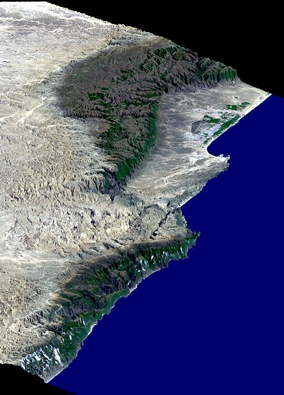
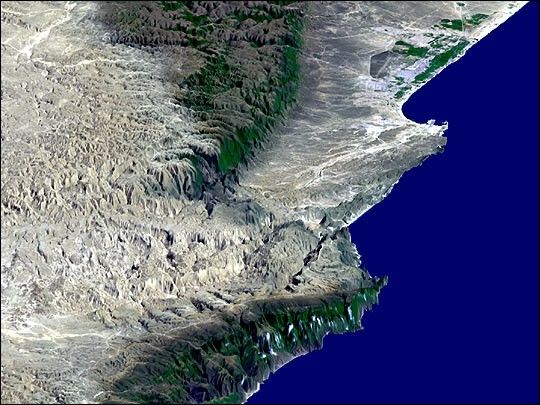
This perspective view includes the city of Salalah, the second largestcity in Oman. The city is located on the broad, generally bright coastalplain and includes areas of green irrigated crops. This view wasgenerated from a Landsat image draped over a preliminary elevation modelproduced by the Shuttle Radar Topography Mission (SRTM). The edges ofthe dataset are to the upper right, left, and lower left. The ArabianSea (lower right) is represented by the blue false-colored area.Vertical exaggeration of topography is 3X.
This scene illustrates how topography determines local climate and, inturn, where people live. The Arabian Peninsula is very arid. However,the steep escarpment of the Qara Mountains wrings moisture from thesummer monsoons allowing for growth of natural vegetation (green alongthe mountain fronts and in the canyons), and soil development (darkbrown areas), as well as cultural development of the coastal plain. Themonsoons also provide moisture for Frankincense trees growing on thedesert (north) side of the mountains. In ancient times, incense derivedfrom the sap of the Frankincense tree was the basis for an extremelylucrative trade.
Landsat satellites have provided visible light and infrared images ofthe Earth continuously since 1972. SRTM topographic data match the30-meter (99-foot) spatial resolution of most Landsat images and providea valuable complement for studying the historic and growing Landsat dataarchive. The Landsat 7 Thematic Mapper image used here was provided tothe SRTM project by the United States Geological Survey, Earth ResourcesObservation Systems (EROS) Data Center, Sioux Falls, South Dakota.
Elevation data used in this image was acquired by SRTM aboard the SpaceShuttle Endeavour, launched on February 11, 2000. SRTM used the sameradar instrument that comprised the Spaceborne Imaging Radar-C/X-BandSynthetic Aperture Radar (SIR-C/X-SAR) that flew twice on the SpaceShuttle Endeavour in 1994. SRTM was designed to collectthree-dimensional measurements of the Earth's surface. To collect the3-D data, engineers added a 60-meter-long (200-foot) mast, installedadditional C-band and X-band antennas, and improved tracking andnavigation devices. The mission is a cooperative project between theNational Aeronautics and Space Administration (NASA), the NationalImagery and Mapping Agency (NIMA) of the U.S. Department of Defense(DoD), and the German and Italian space agencies. It is managed byNASA's Jet Propulsion Laboratory, Pasadena, CA, for NASA's Earth ScienceEnterprise, Washington, DC.
Size: 45 kilometers (28 miles) across x 178 kilometers (110 miles) distance
Location: 17 deg. North lat., 54 deg. East lon.
Orientation: North toward upper left
Image Data: Landsat bands 1, 2+4, 3 in blue, green, red
Date Acquired: February 15, 2000 (SRTM), November 9, 1999 (Landsat)
References & Resources
Image by NASA/JPL/NIMA