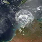















On January 24, 2007, a minor cloud system blossomed in the Indian Ocean between Indonesia and northwestern Australia. The storm lacked the circulation of a tropical storm, so it never received a name. It did not strike any major populated centers, so it never was a news item. But newsworthy and fascinating are not always the same thing, and the symmetrical shape of the storm and the apparently expanding ring of cloud ripples shown in this image suggest some intriguing atmospheric physics in action.
This photo-like image was acquired by the Moderate Resolution Imaging Spectroradiometer (MODIS) on the Terra satellite on January 24, 2007, at 10:10 a.m. local time (2:10 UTC). The circular cloud system in the image was driven by powerful thunderstorms that previously raged beneath the now-ragged cirrus clouds at the system’s center.
The clouds formed from an afternoon convection system, a vigorous overturning of the air that is common this time of year near Australia’s tropical northern coast. The system traveled westward over Austalia’s Northern Territory, eventually reaching the coast of Western Australia. Over the Indian Ocean, the cloud system grew rapidly, drawing warm, moist ocean air up into the top of the storm. At the top of this convection system, the air ceased to flow upward and spilled out into an expanding ring.
This same process almost always occurs in thunderstorms, but in this case there appears to have been relatively constant wind through a deep layer of the atmosphere, allowing the uplifted air to spread out equally in all directions. The clouds at the top of the storm dispersed as an expanding disk of cirrus cloud. The outflowing air may also have disturbed and amplified existing clouds, making them more reflective. Increased reflection of sunlight makes the clouds seem more brightly white to the MODIS sensor.
References & Resources
NASA image by Jesse Allen, Earth Observatory, using data provided courtesy of the MODIS Rapid Response Team, Goddard Space Flight Center. Image interpretation provided by George Huffman, NASA Goddard Space Flight Center.