


- Quicktime (.mov) format (1 MB)
- MPEG-1 (.mpg) format (1.3 MB)
Gafilo struck the northeast coast of Madagascar early on the morningof the 7th of March 2004 (LST) as a very powerful Category 5 cyclonewith winds estimated at 160 mph. So far, at least 25 people havebeen reported dead on Madagascar not counting a further 111 feareddrowned on a ferry that was lost in the storm and reported to havecapsized in heavy seas by two survivors. After making landfall on thenortheast coast, Gafilo cut across the northern part of the islandmoving southwest leaving as many as 100,000 people homeless in itswake before re-emerging over the waters of the Mozambique Channel onMarch 8th. Out over the channel, Gafilo recurved heading southeast.It briefly regaining Category 1 strength over open waters. The stormthen made landfall again on the night of the 9th along the southwestcoast of Madagascar and crossed the island yet again, this time overthe southern part of the island. Gafilo is finally forecast to exitthe southeast coastline of Madagascar on the evening of the 11thand head back out into the western Indian ocean as a weak tropicalstorm.
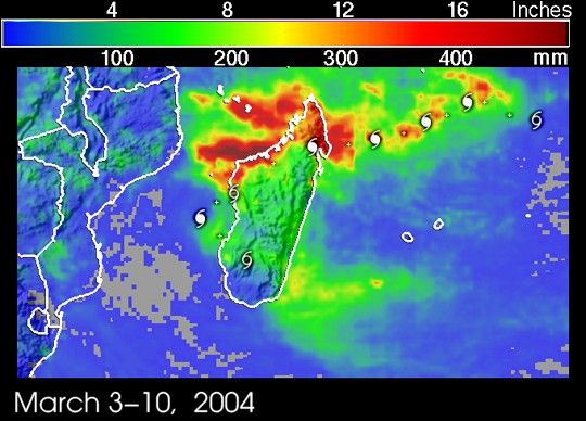
The TRMM-based, near-real time Multi-satellite Precipitation Analysis(MPA) at the NASA Goddard Space Flight Center monitors rainfall overthe global tropics. MPA rainfall totals are shown for the period 3-10March 2004 for the area over and around Madagascar. Cyclone symbolsmark the 06Z positions of Gafilo along its path. As the stormapproaches Madagascar from the east, the heaviest rainfall totals, onthe order of 12 inches (orange-red areas), appear close to the centerof the storm track. As the systems crosses land, the higher totalsappear to the right of the storm track and are on the order of 15inches of rain (red area) over the northern tip of Madagascar. Theheaviest totals of up to 20 inches (darkest reds) stretch from thecentral Mozambique Channel eastward to along the northwest coastlineof Madagascar. These totals appear to be associated with an intense,east-west oriented rainband that was observed by TRMM on March 8 (seethe previous story on Gafilo) well north of the storm's center.Rainfall totals are significantly less though still on the order of4 to 8 inches (green areas) over southern and central Madagascar.
TRMM is a joint mission between NASA and the Japanese space agency JAXA.
References & Resources
Image produced by Hal Pierce (SSAI/NASA GSFC) and caption by Steve Lang (SSAI/NASA GSFC).


