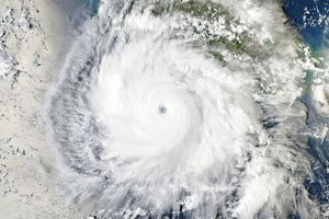
Giovanna formed as a tropical storm over the southern Indian Ocean on February 9, 2012, and strengthened to a tropical cyclone the next day. On February 10, the U.S. Navy’s Joint Typhoon Warning Center (JTWC) reported that Giovanna had maximum sustained winds of 65 knots (120 kilometers per hour) and gusts up to 80 knots (150 kilometers per hour). Located roughly 480 nautical miles (890 kilometers) northeast of Réunion, the storm was moving toward the west-southwest.
The Moderate Resolution Imaging Spectroradiometer (MODIS) on NASA’s Terra satellite captured this natural-color image on February 10, 2012. Giovanna hovers over the Indian Ocean, east of Madagascar.
The JTWC forecast that Giovanna would intensify over the next day and a half, reaching wind speeds of 110 knots (205 kilometers per hour). After making landfall on Madagascar, Giovanna was expected to temporarily weaken, but regain strength over the Mozambique Channel, where warm waters fueled Tropical Cyclone Funso in January 2012.
References & Resources
- Joint Typhoon Warning Center. (2012, February 10). Tropical Cyclone 12S (Giovanna) Warning. Accessed February 10, 2012.
- Unisys Weather. (2012, February 10). Giovanna Tracking Information. Accessed February 10, 2012.
NASA image courtesy Jeff Schmaltz, LANCE/EOSDIS MODIS Rapid Response Team at NASA GSFC. Caption by Michon Scott.