


- Quicktime (.mov) format (4.9 MB)
- MPEG-1 (.mpg) format (1.3 MB)
Tropical Storm Larry formed in the Bay of Campeche in the southernGulf of Mexico on the evening of October 1, 2003. Larryremained a tropical storm with winds reaching up to 60 mphas estimated by the National Hurricane Center. Larry was nearlystationary at times, and slowly drifted southward before comingashore near Coatzacoalcos, Mexico on the Gulf Coast side of southernMexico on the morning of the 5th.
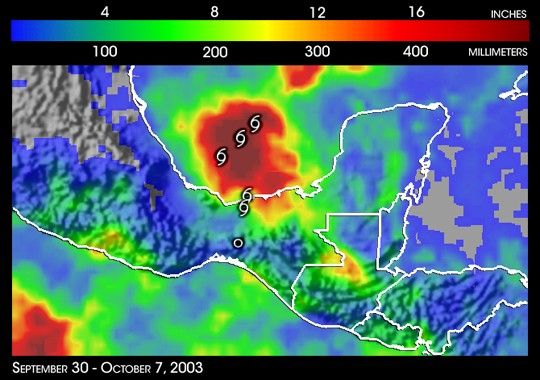
The primary threat from Larry wasflooding due to the storm's slow forward speed. The TRMM-based,near-real time Multi-satellite Precipitation Analysis (MPA) at theNASA Goddard Space Flight Center shows rainfall totals associated withLarry for the period September 30 to October 7, 2003. Fortunately,the heaviest amounts, on the order of 20 inches (darkest reds), appearoffshore. However, coastal areas received up to a foot of rain (redareas) with 4 to 10 inches (green to yellow areas) occurring inlandbetween the coast and the highlands of the southern Sierra Madre.
Tropical storm symbols mark the positions of Larry every 24 hoursbeginning at 7 pm CDT on October 1 as reported by the NationalHurricane Center. Larry first drifted towards the southwest thenjogged to the southeast before continuing to move southward.
TRMM is a joint mission between NASA and the Japanese space agency NASDA.
References & Resources
Image generated by Hal Pierce (SSAI/NASA GSFC) and caption by Steve Lang (SSAI/NASA GSFC).


