On August 28, 2012, Tropical Storm Bolaven left five fishermen dead and 10 more missing in waters around Jeju (Cheju) Island, off the southern tip of the Korean Peninsula. As Bolaven moved north along South Korea’s west coast, it left about 200,000 households without power, and forced the cancellation of flights and ferry services. Bolaven was due to make landfall in North Korea later in the day.
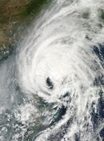
The Moderate Resolution Imaging Spectroradiometer (MODIS) on NASA’s Aqua satellite captured this natural-color image of Tropical Storm Bolaven on August 28. Storm clouds covered the Korean Peninsula, Korea Bay, and Bo Hai, as well as parts of the Yellow Sea and the Sea of Japan.
The same day that MODIS acquired this image, the U.S. Navy’s Joint Typhoon Warning Center (JTWC) reported that Bolaven had maximum sustained winds of 55 knots (100 kilometers per hour) and gusts up to 70 knots (130 kilometers per hour). The JTWC projected storm track showed Bolaven heading toward the north-northeast, over North Korea, China, and Russia.
References & Resources
- CNN. (2012, August 28) 5 fishermen dead, 10 missing as Typhoon Bolaven reaches Korean Peninsula. Accessed August 28, 2012.
- Joint Typhoon Warning Center. (2012, August 28) Typhoon 16W (Bolaven) Warning. [Online] URL: http://www.usno.navy.mil/NOOC/nmfc-ph/RSS/jtwc/warnings/wp1612web.txt. Accessed August 28, 2012.
- Unisys Weather. (2012, August 28) Bolaven Tracking Information. Accessed August 28, 2012.
NASA image courtesy Jeff Schmaltz, LANCE MODIS Rapid Response Team at NASA GSFC. Caption by Michon Scott.