Suggested Searches

1 min read

Typhooon Chanthu

Instruments:
Typhooon Chanthu
June 12, 2004

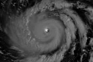
The MODIS instrument onboard NASA's Terra satellite captured this true-color image of Typhoon Chanthu as it was bearing down on the the coast of Vietnam on June 12 at 3:15 UTC. At that time, Chanthu was packing sustained winds of 86 mph with gusts to 104 mph and was expected to intensify further before moving inland.

References & Resources

Image courtesy Jesse Allen, NASA's Earth Observatory. NASA GSFC, MODIS Rapid Response Team

You may also be interested in:

Stay up-to-date with the latest content from NASA as we explore the universe and discover more about our home planet.

June 2026 Satellite Puzzler
2 min read

Your challenge is to tell us the location of the satellite image and why it is interesting.

Article
Snow in the Shadow of the Andes
2 min read

An early autumn storm left higher elevations in southern Argentina with a fresh and fleeting coat of white.

Article
Super Typhoon Bavi
3 min read

The third category 5 tropical cyclone of 2026 crossed the U.S. Northern Mariana Islands and Guam before continuing toward Asia.

Article