


At 1:20 p.m. local time (05"20 Universal Time) on December 14, 2015, the Moderate Resolution Imaging Spectroradiometer (MODIS) on NASA’s Aqua satellite captured this view of Typhoon Melor over the eastern Philippines. (Locally, the storm is known as Typhoon Nona.)
Melor first made landfall over Northern Samar a few hours before this image was acquired. The typhoon continued westward with maximum sustained winds of 150 kilometers (90 miles) per hour. More than 720,000 people were evacuated in advance of the storm.
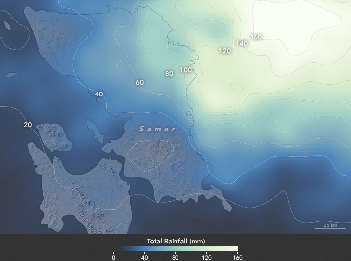
In addition to damaging winds, Melor was expected to bring heavy rains and flooding to some areas. The second image shows a satellite-based estimate of rainfall in the span of one day, starting at 10:30 a.m. local time (02"30 UTC) on December 13. The rainfall data come from the Integrated Multi-Satellite Retrievals for GPM (IMERG), a product of the Global Precipitation Measurement mission. The brightest shades represent rainfall totals approaching 160 millimeters (6.3 inches) during the 24-hour period.
References & Resources
- Joint Typhoon Warning Center (2015, December 14) Warning Text. Accessed December 14, 2015.
- National Disaster Risk Reduction and Management Council (2015, December 14) SitRep No. 04 re Preparedness Measures for Typhoon “NONA” (I.N. MELOR). Accessed December 14, 2015.
- Philippine Atmospheric, Geophysical and Astronomical Services Administration (2015, December 14) Tropical Cyclone Update. Accessed December 14, 2015.
- Philstar (2015, December 15) Thousands flee, classes suspended as Nona makes landfall. Accessed December 14, 2015.
NASA Earth Observatory image (top) by Jesse Allen, using data from the Land Atmosphere Near real-time Capability for EOS (LANCE). NASA Earth Observatory map (bottom) by Joshua Stevens, using IMERG data provided courtesy of the Global Precipitation Mission (GPM) Science Team's Precipitation Processing System (PPS). Caption by Kathryn Hansen.


