


- May 14, 2004 (436 KB)
- May 17, 2004 (512 KB)
- Quicktime (.mov) format (1.8 MB)
- MPEG-1 (.mpg) format (520 KB)
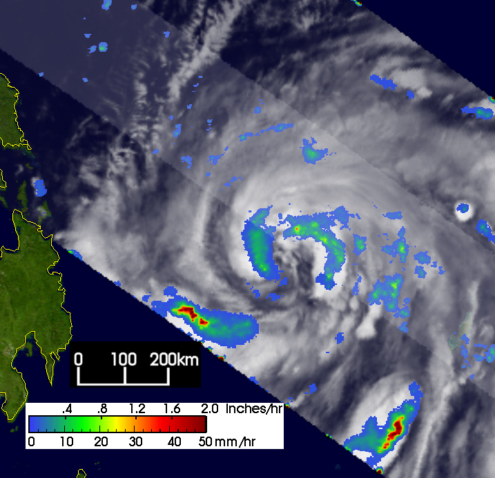
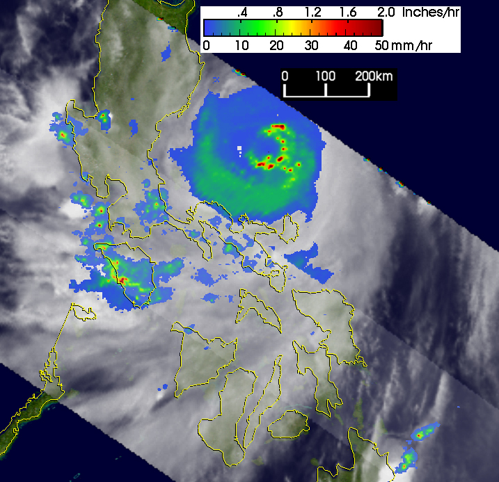
The main islands of the Philippines have thus far been spared the brunt ofSuper Typhoon Nida (known as Dindo in the Philippines) though the easternisland of Catanduanes was not as fortunate. A tropical depression formedon the 13th of May 2004 about 500 km (300 miles) east of the southernPhilippines island of Mindanao and initially moved west. By late the next day on the 14th, thesystem had already become a minimal typhoon (named Nida) with maximumsustained winds estimated at 65 knots (75 mph) by the Joint Typhoon WarningCenter and was now moving almost due north. On the 15th, Nida continued tointensify reaching 90 knots (104 mph) and settled into a northwestly track.The next 24 hours saw Nida steadily intensify becoming a super typhoon withmaximum sustained winds of 140 knots (161 mph) on the 16th as it camedangerously close to the central Philippines island of Samar. Samar avoideda direct hit, but Nida slammed into the island of Catanduanes the next dayon the morning of the 17th where there were reports of deadly mudslides.As of the 17th Nida was located roughly 200 miles east of Luzon in thePhilippine Sea and moving north northwest. On it's present course the eyeis not expected to cross Luzon.
The Tropical Rainfall Measuring Mission (TRMM) satellite captured a seriesof images showing the evolution of Nida. The first image was taken at 14:14UTC on 13 May 2004. It shows the horizontal distribution of rain intensity.Rain rates in the center swath are from the TRMM Precipitation Radar (PR),while rain rates in the outer swath are from the TRMM Microwave Imager (TMI).The rain rates are overlaid on infrared (IR) data from the TRMM VisibleInfrared Scanner (VIRS). At the time of the first image, Nida was still just atropical storm. TRMM shows that the storm is still organizing with noevidence of an eye yet. Mainly moderate (green) to light (blue areas) rainrates are present near the center. The next image taken at 13:19 UTC onthe 14th shows Nida becoming better organized. More banding is evident inthe rain field (green arcs) though the eye is still poorly defined. Thefinal image was taken at 12:09 UTC on May 17th after Nida had passed overCatanduanes. Thought the PR did not pass over the center, the TMI shows anearly complete well-formed eye with embedded areas of intense rain (redareas). Having just passed over the island of Catanduanes, the center islikely showing the effects of being disrupted by the island's terrain.
TRMM is a joint mission between NASA and the Japanese space agency JAXA.
References & Resources
Images produced by Hal Pierce (SSAI/NASA GSFC) and caption by Steve Lang (SSAI/NASA GSFC).


