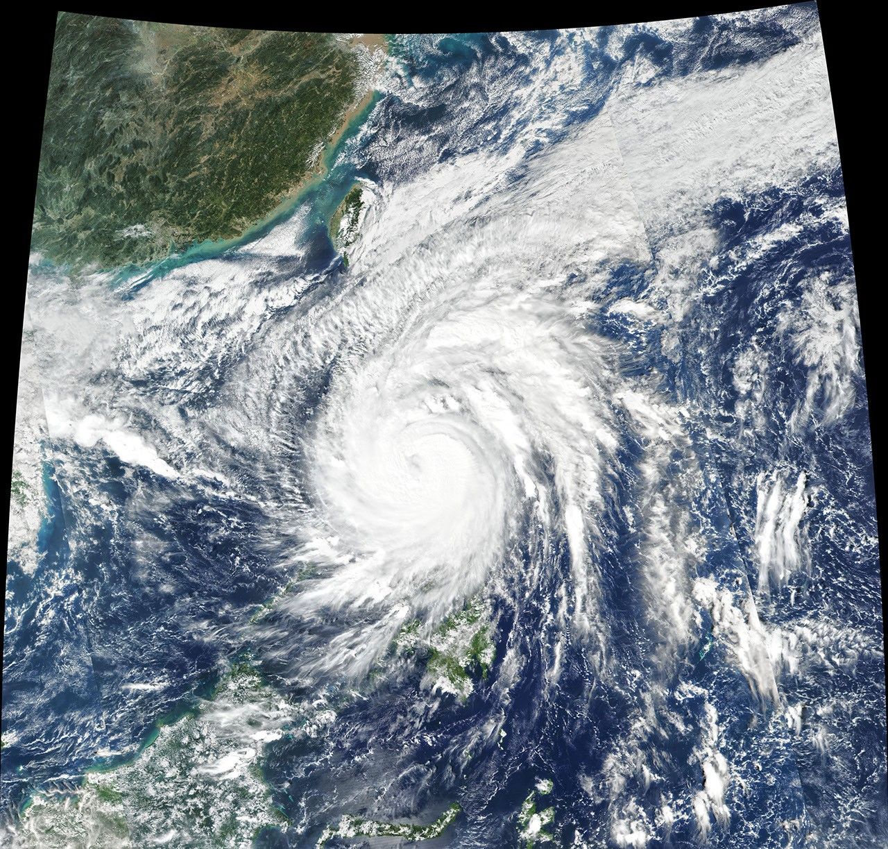


On November 11, 2020, Typhoon Vamco thrashed the Philippines with sustained winds of 150 kilometers (90 miles) per hour. The typhoon (known as Ulysses in the Philippines) cut power to millions, caused more than 100,000 evacuations, and killed at least six people.
The image above shows the typhoon on November 11 at 1:05 p.m. Philippines Standard Time (05:05 Universal Time), a few hours before the typhoon made landfall. The image was acquired by the Visible Infrared Imaging Radiometer Suite (VIIRS) on the Suomi NPP satellite.
The storm first made landfall in Patnanungan, Quezon, around 10:30 p.m. and then continued west to hit the island of Luzon, where Manila saw its worst flooding in years. A river in Marikina, located in the Manila metropolitan area, was reported to have risen a meter (3 feet) in less than three hours. As of November 12, several dams were in danger of overflowing due to the heavy rains.
The typhoon is now crossing the South China Sea, but the agency still warned of flash floods, rain-induced landslides, and sediment-laden streams in areas in the Philippines. The country has been hit directly or partially by eight different storms since the start of October 2020. Vamco comes less than two weeks after Super Typhoon Goni brought heavy rain and winds upward of 310 kilometers (195 miles) to the same regions.
References & Resources
- CNN (2020, November 12) Several killed and 180,000 evacuated as Typhoon Vamco hits the Philippines. Accessed November 12, 2020.
- Manila Bulletin (2020, November 11) La Mesa, Angat, Magat, Caliraya dams readied for strong rains from âUlyssesâ. Accessed November 12, 2020.
- Philippine Atmospheric, Geophysical and Astronomical Services Administration (2020, November 12) Typhoon âUlyssesâ. Accessed November 12, 2020.
- ReliefWeb (2020, November 12) Philippines: Typhoon Vamco (Ulysses) Snapshot (As of 12 November 2020). Accessed November 12, 2020.
- Reuters (2020, November 11) Seven dead as Typhoon Vamco triggers Philippine capitalâs worst floods in years. Accessed November 12, 2020.
NASA Earth Observatory image by Joshua Stevens , using VIIRS data from NASA EOSDIS/LANCE and GIBS/Worldview and the Suomi National Polar-orbiting Partnership . Story by Kasha Patel .