


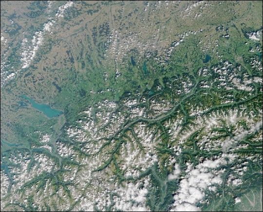
Here's another chance to play geographical detective! This Multi-angleImaging SpectroRadiometer (MISR) image covers an area measuring 355kilometers x 287 kilometers, and was captured by the instrument'svertical-viewing (nadir) camera on August 14, 2000.This mystery concerns the large lake near the left-hand side of the image,halfway down from the top. Use any reference materials you like and answerthe following three questions:
- The lake has two commonly used names. What are they?
- What process formed the lake's basin?
- Meteor impact,
- Human excavation,
- Glacial erosion,
- Volcanic activity.
- There is an international airport within 100 kilometers,
- Remedial efforts to mitigate eutrophication were first initiated in the 1990's,
- Millions of people rely on the lake for drinking water,
- A lakeside town hosts an annual celebration of Celtic music.
E-mail your answers, name (initials are acceptable if you prefer), and yourhometown by Monday, August 13, 2001 to suggestions@mail-misr.jpl.nasa.gov.
Answers will be published on theMISR web sitein conjunction with the next weekly image release. The names and home townsof respondents who answer all questions correctly by the deadline will alsobe published in the order responses were received. The first 3 people onthis list who are not affiliated with NASA, JPL, or MISR and who did notwin a prize in the last quiz will be sent a print of the image.
In light of the great response to the recent "What Place is This?" quiz, anew "Where on Earth...?" mystery will appear as the MISR "image of theweek" approximately once per month. A new image of the week is releasedevery Wednesday at noon Pacific time on theMISR home page.The image also appears on theJPL Planetary Photojournal,and on the Atmospheric SciencesData Center home page, though usually with a several-hour delay.
Good luck!
References & Resources
Image courtesy NASA/GSFC/LaRC/JPL, MISR Team.


