


On July 24, 2024, lightning ignited what became known as the Wapiti fire in central Idaho. Fire activity ramped up in late August, expanding its footprint to over 100,000 acres (400 square kilometers) by early September. The Wapiti fire, as well as the Middle Fork Complex fires burning nearby, have spurred evacuation orders and highway and public lands closures.
The OLI (Operational Land Imager) on Landsat 8 acquired these images of fire activity on August 31, 2024, at about 12:30 p.m. local time (18:30 Universal Time). Thick smoke fills the valleys, while plumes from active blazes drift to the north. At this point, the Wapiti fire, on the right side of the image, had reached about 95,000 acres, and its perimeter was uncontained. Fires in the Middle Fork Complex, which spanned about 55,000 acres on this date, burn on the left side of the image.
On the morning of August 31, a temperature inversion—a warm layer of air capping a cooler one—trapped smoke in low-lying areas. Inversions can suppress fire activity by preventing sunlight and heat from reaching the ground. According to InciWeb, forecasters expected the inversion to lift around noon, with the potential for fire behavior to increase after that.
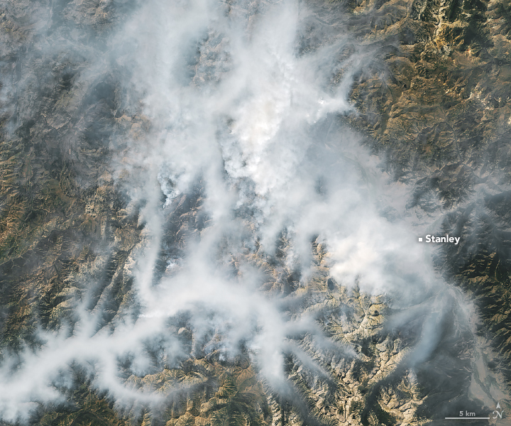
The Wapiti fire, shown in this detailed image, had burned about 9,000 acres (36 square kilometers) in its first month. After August 20, it expanded much more rapidly. By September 3, it had grown twelve times larger to approximately 108,000 acres. As fire activity increased, officials ordered the closure of portions of the Boise, Sawtooth, and Salmon-Challis national forests and nearly 50 miles of State Highway 21 heading west out of Stanley. Residents in and around Stanley were issued evacuation orders or preparation notices. Ground-based photographers captured images of dense smoke plumes and red skies.
On September 3, more fire weather was in store for the area. A red flag warning was in effect through the evening, with scattered thunderstorms and wind gusts up to 50 miles (80 kilometers) per hour in the forecast.
References & Resources
- Idaho Capital Sun (2024, August 27) Idaho’s Wapiti Fire surpasses 70,000 acres; containment at 0%. Accessed September 3, 2024.
- Idaho Statesman (2024, August 29) Evacuations ordered near Stanley as wildfire grows. Idaho Highway 21 closure extended. Accessed September 3, 2024.
- InciWeb (2024, September 3) Middle Fork Complex Fire: Bulldog, Nellie, Anderson. Accessed September 3, 2024.
- InciWeb (2024, September 3) Wapiti Fire. Accessed September 3, 2024.
- National Weather Service Boise (2024, September 3) Red Flag Warning. September 3, 2024.
- The University of Utah (2019, September 11) “Fire Inversions” Lock Smoke in Valleys. Accessed September 3, 2024.
NASA Earth Observatory images by Michala Garrison, using Landsat data from the U.S. Geological Survey . Story by Lindsey Doermann .


