


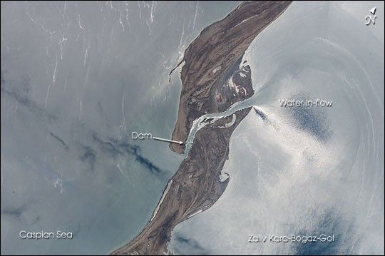
The large eastern embayment of the Caspian Sea, the Zaliv Kara-Bogaz-Gol,provides astronauts the chance to observe several oceanographic phenomena. Thisview taken by the STS-111 crew from the Space Shuttle in June 2002 shows the sunreflecting off the surface waters that surround the spit that defines the ZalivKara-Bogaz-Gol from the open Caspian Sea. The sunglint reveals the flow offresher water through the spit channel and into the bay. Old shorelines andaccretionary features can be seen on the spit, as well as the dam that wasconstructed in 1980 to stop the flow into the lower Kara-Bogaz-Golbasin.
The Caspian Sea has experienced dramatic changes in water levels throughoutthe past 100 years. From the 1930s until 1978, the water levels in the Caspianhad dropped nearly 3 m. In 1980, in response to the rapidly dropping sea level,a dam was constructed to prevent water from flowing into the shallow andrestricted Kara-Bogaz-Gol basin, resulting in the drying up of the bay. The damwas partially opened a few years later, and completely opened in 1992 whenCaspian water levels started to rise quickly. Today, sea levels are more than2.6 m higher than the 1978 levels, and, as shown here, water flows freely intothe salty waters of the Zaliv Kara-Bogaz-Gol. Astronauts have also beendocumenting the coastlines around the Caspian Sea that have been impacted by thelarge sea level fluctuations.
References & Resources
Astronaut photograph STS111-E-5485 was provided by the Earth Sciences and Image Analysis Laboratory at Johnson Space Center. Additional images taken by astronauts and cosmonauts can be viewed at the NASA-JSC Gateway to Astronaut Photography of Earth .


