


before
after

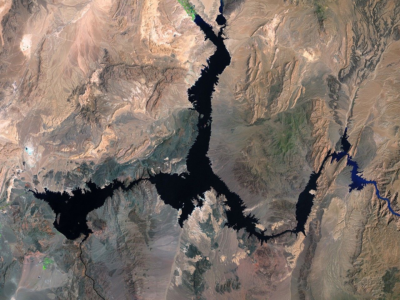
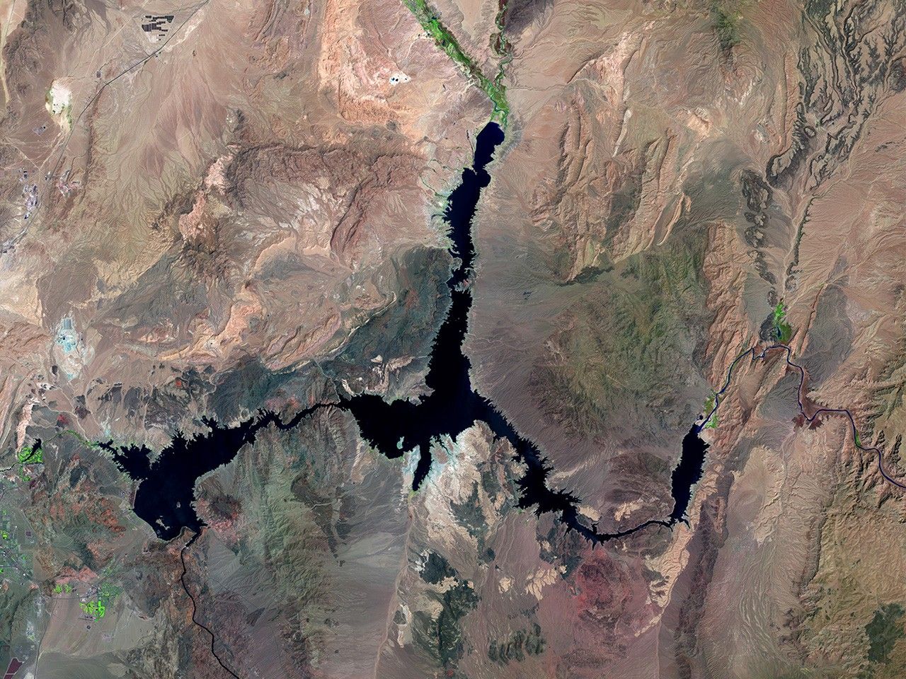
Lake Mead, the largest reservoir in the U.S., has fallen to the lowest level since it began filling in the 1930s, the result of 16 years of drought in the Colorado River Basin. The 1984 image shows the lake nearly full, compared to 37 percent full in the 2016 image. Lake Mead supplies water to 25 million people, including virtually all of Las Vegas and farms, tribes and businesses in Arizona, California, Nevada and northern Mexico. Also see this image pair. Images taken by the Thematic Mapper on board Landsat 5 and the Operational Land Imager onboard Landsat 8. Source: U.S. Geological Survey (USGS) Landsat Missions Gallery; Lake Mead Reaches Historic Low; U.S. Department of the Interior / USGS and NASA.

Lake Mead, the largest reservoir in the U.S., has fallen to the lowest level since it began filling in the 1930s, the result of 16 years of drought in the Colorado River Basin. The 1984 image shows the lake nearly full, compared to 37 percent full in the 2016 image. Lake Mead supplies water to 25 million people, including virtually all of Las Vegas and farms, tribes and businesses in Arizona, California, Nevada and northern Mexico. Also see this image pair. Images taken by the Thematic Mapper on board Landsat 5 and the Operational Land Imager onboard Landsat 8. Source: U.S. Geological Survey (USGS) Landsat Missions Gallery; Lake Mead Reaches Historic Low; U.S. Department of the Interior / USGS and NASA.
Lake Mead, the largest reservoir in the U.S., has fallen to the lowest level since it began filling in the 1930s, the result of 16 years of drought in the Colorado River Basin. The 1984 image shows the lake nearly full, compared to 37 percent full in the 2016 image. Lake Mead supplies water to 25 million people, including virtually all of Las Vegas and farms, tribes and businesses in Arizona, California, Nevada and northern Mexico. Also see this image pair. Images taken by the Thematic Mapper on board Landsat 5 and the Operational Land Imager onboard Landsat 8. Source: U.S. Geological Survey (USGS) Landsat Missions Gallery; Lake Mead Reaches Historic Low; U.S. Department of the Interior / USGS and NASA.
Lake Mead, the largest reservoir in the U.S., has fallen to the lowest level since it began filling in the 1930s, the result of 16 years of drought in the Colorado River Basin. The 1984 image shows the lake nearly full, compared to 37 percent full in the 2016 image. Lake Mead supplies water to 25 million people, including virtually all of Las Vegas and farms, tribes and businesses in Arizona, California, Nevada and northern Mexico. Also see this image pair. Images taken by the Thematic Mapper on board Landsat 5 and the Operational Land Imager onboard Landsat 8. Source: U.S. Geological Survey (USGS) Landsat Missions Gallery; Lake Mead Reaches Historic Low; U.S. Department of the Interior / USGS and NASA.
before
after
Before and After
Lake Mead at record low
May 15, 1984 - May 23, 2016
Lake Mead, the largest reservoir in the U.S., has fallen to the lowest level since it began filling in the 1930s, the result of 16 years of drought in the Colorado River Basin. The 1984 image shows the lake nearly full, compared to 37 percent full in the 2016 image. Lake Mead supplies water to 25 million people, including virtually all of Las Vegas and farms, tribes and businesses in Arizona, California, Nevada and northern Mexico. Also see this image pair. Images taken by the Thematic Mapper on board Landsat 5 and the Operational Land Imager onboard Landsat 8. Source: U.S. Geological Survey (USGS) Landsat Missions Gallery; Lake Mead Reaches Historic Low; U.S. Department of the Interior / USGS and NASA


