




























APOD
Astronomy Picture of the Day
Discover the cosmos! Each day a different image or photograph of our fascinating universe is featured, along with a brief explanation written by a professional astronomer.
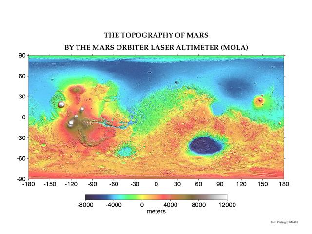
The Topography of Mars
Explanation: Mars has its ups and downs. Visible on the above interactive topographic map of the surface of Mars are giant volcanoes , deep valleys , impact craters , and terrain considered unusual and even mysterious . Particularly notable are the volcanoes of the Tharsis province , visible on the left in (false-color) red and white, which are taller than any mountains on Earth . Just to the left of center is Valles Marineris , a canyon much longer and deeper than Earth's Grand Canyon . On the right in blue is the Hellas Planitia , a basin over 2000 kilometers wide that was likely created by a collision with an asteroid . Mars has many smooth lowlands in the north , and many rough highlands in the south . This map was created by the Mars Orbital Laser Altimeter (MOLA) on board the robot Mars Global Surveyor currently orbiting Mars . MOLA measures heights on Mars by precisely determining the time it takes for a low power laser beam to bounce off the surface. Zoom in by clicking anywhere on the above map .
| Date | June 28, 2001 |
|---|---|
| Credit | Credit: MOLA Science Team , MGS , NASA |
| Authors & editors: | Robert Nemiroff (MTU) & Jerry Bonnell (UMCP) |
| A service of: |
ASD at NASA / GSFC, NASA Science Activation & Michigan Tech. U. |