


About LRO
In Depth: Lunar Reconnaissance Orbiter
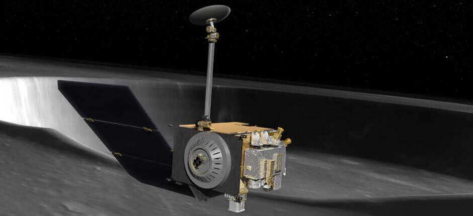
The Lunar Reconnaissance Orbiter (LRO) launched to the Moon with the Lunar Crater Observation and Sensing Satellite (LCROSS) in 2009.
LRO’s initial goals included: make a 3D map of the Moon’s surface from lunar polar orbit as part of a high-resolution mapping program to identify landing sites and potential resources, investigate the Moon's radiation environment, and prove new technologies in anticipation of future automated and human missions.
The Centaur upper stage boosted both LRO and LCROSS into high apogee orbits soon after launch. At 11:27 UT June 23, 2009, LRO successfully entered orbit around the Moon, having fired its rocket motor on the far side of the Moon. Initial orbital parameters were roughly 19 x 134 miles (30 × 216 kilometers).
A series of four engine firings over the next four days left LRO in its optimal orbit—roughly circular at 31 miles (50 kilometers)—allowing the satellite to begin its primary mission on Sept. 25, 2009. The primary mission was expected to last one year and was overseen by NASA’s Exploration Systems Mission Directorate (ESMD).
LRO gathered information on day-night temperature maps, contributed data for a global geodetic grid, and conducted high-resolution imaging. The spacecraft team paid particular attention to the Moon’s polar regions where scientists suspected there might be water in the permanently shadowed areas. (In 2018, a team of scientists directly observed definitive evidence of water ice on the Moon’s surface. At the southern pole, most of the ice is concentrated at lunar craters, while the northern pole’s ice is more widely, but sparsely, spread.)
In September 2010, NASA’s Science Mission Directorate (SMD) took over LRO operations. The orbiter continues to produce new science data and supply crucial information for exploration planning.
In November 2011, NASA released the highest resolution near-topographical map of the Moon ever created, showing surface features over nearly the entire Moon. An interactive mosaic of the lunar north pole was published in March 2014.
LRO also carried out the first demonstration of laser communication with a lunar satellite when, in January 2013, NASA scientists beamed an image of the Mona Lisa from the Next Generation Satellite Laser Ranging (NGSLR) station at NASA’s Goddard Space Flight Center in Greenbelt, Maryland, to the lunar orbiter laser altimeter (LOLA) on LRO.
One of the LRO instruments, the Mini-RF, partially failed in January 2011, although fortunately, it had already completed its primary science objectives by that time.
On May 4, 2015, controllers at Goddard Space Flight Center sent commands to LRO to fire its engines twice to change its orbit, taking it closer to the Moon than before—a polar orbit of about 12 x 102 miles (20 × 165 kilometers). Perilune, the point at which the spacecraft was closest to the Moon, was near the lunar south pole.
The new orbit allowed LRO’s LOLA instrument to produce better return signals and also allowed it to better measure specific regions near the south pole that have unique illumination conditions.
During the total solar eclipses of Aug. 21, 2017 and April 8, 2024, LRO captured images of the Moon’s shadow over large regions of the U.S.
In May 2018, due to evidence that LRO’s inertial measurement unit (IMU) was nearing the end of its life, the LRO team powered down the unit to reserve its remaining life for highly critical events, such as lunar eclipses and safe mode entries. The IMU contains a set of three ring laser gyroscopes which are used to measure the rotation of the spacecraft in each of three axes.
In March 2019, scientists reported they had used LRO’s Lyman-Alpha mapping project (LAMP) to observe water molecules moving around the dayside of the Moon. The measurements helped characterize lunar hydration changes over the course of a day.
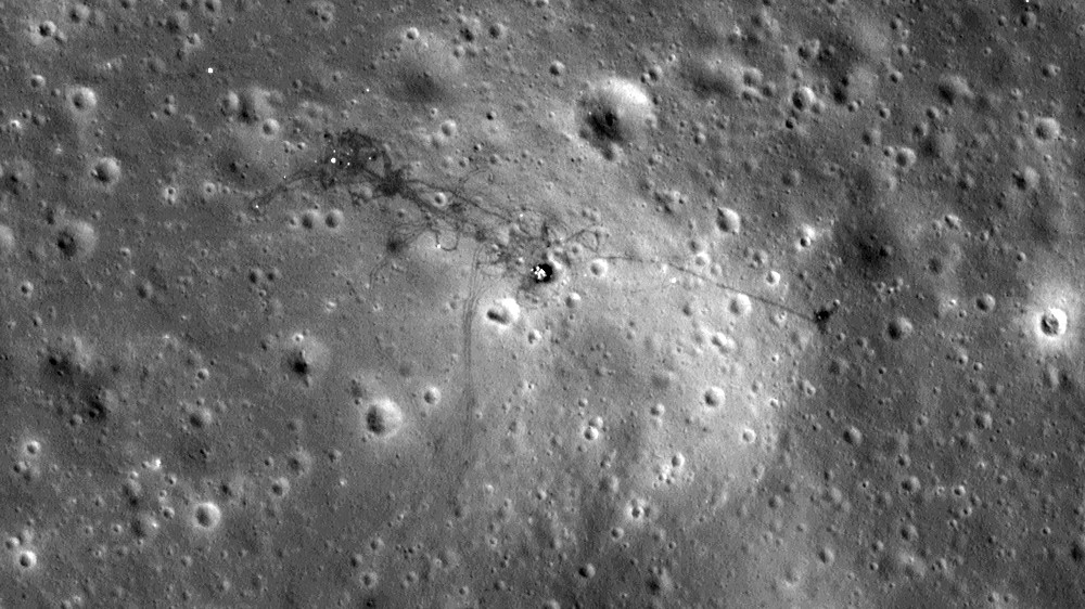
In addition to mapping the Moon’s natural features, LRO has taken extremely high-resolution photographs of landing sites of several older lunar landers and impact vehicles, incuding all of the Apollo landing sites (plus Surveyor III near the Apollo 12 site), the Apollo 13, 14, 15 and 17 Saturn IVB upper stages, and the hitherto unknown impact site of Apollo 16’s S-IVB upper stage, which was deliberately impacted on the lunar surface in 1972. Other targets included the later Ranger impact probes, the Soviet Luna 16, 17, 20, 23 and 24 soft-landers, and China’s Chang’e 3 and Chang’e 4 landers and rovers.
Initial data sets from LRO were deposited in the Planetary Data System (PDS), a publicly accessible repository of planetary science information, within six months of primary mission completion. Thereafter, the data sets have been deposited in the PDS every three months. The processed data sets deepen our understanding of the lunar environment, paving the way for a safe human return to the Moon and for future human exploration of our solar system.
Quick Facts
| Nation | United States of America (USA) |
| Objective(s) | Lunar Orbit |
| Spacecraft | LRO |
| Spacecraft Mass | 4,000 pounds (1,850 kilograms) |
| Mission Design and Management | NASA / GSFC |
| Launch Vehicle | Atlas V 401 (no. AV-020) |
| Launch Date and Time | June 18, 2009 / 21:32:00 UT |
| Launch Site | Cape Canaveral Air Force Station, Fla. / SLC-41 |
| Scientific Instruments | Cosmic Ray Telescope for the Effects of Radiation (CRaTER)Diviner Lunar Radiometer Experiment (DLRE)Lyman-Alpha Mapping Project (LAMP)Lunar Exploration Neutron Detector (LEND)Lunar Orbiter Laser Altimeter (LOLA)Lunar Reconnaissance Orbiter Camera (LROC)Mini-RF Miniature Radio Frequency Radar |
Firsts & Technical Innovations
- Provided data for the highest resolution near-topographical map of the Moon to date
- Carried out the first demonstration of laser communication with a lunar satellite
- First deep space precision orbit determination by laser ranging from Earth
- First global thermal mapping of a planetary body covering a full range of local times and seasons
- First bi-static radar imaging measurements from Earth to a planetary orbiter
- First multi-beam laser altimeter system in space
- More than five years of laser altimetric measurements yielding more than 8 billion topographic points, better than any other object in the solar system
- First collimated epithermal neutron detectors in space
- First use of tissue-equivalent-plastic (TEP) in deep space radiation detectors.
- First radar measurements of the lunar farside
Key Dates
- Jun. 18, 2009: Launch
- Jun. 23, 2009: Inserted into lunar orbit
Selected Science Highlights
- In polar shadowed regions, found the coldest spots measured (below 30 K) in the solar system
- Discovered significant subsurface hydrogen deposits in regions cold enough for water ice to survive, as well as in additional hydrogen deposits in warmer areas where surface water ice is not thermally stable
- Measured surprising amounts of several volatiles (e.g.,CO, H2, and Hg) in the gaseous cloud released from Cabeus by the LCROSS impact
- New (<5 years old) impact craters and are found to be widespread across the lunar surface, with a surprising abundance of related surface changes
- Developed an improved catalogue of lunar craters larger than 20 km in diameter, thus providing constraints on the ancient impactor population that affected the inner solar system
- Improved the age dating of small landforms by using crater counts from the new high-resolution images
- Discovered that the Moon is in a general state of relatively recent (<1 Ga) contraction
- Characterized relatively young volcanic complexes, such as Ina, and revealed first direct evidence of the presence of highly silicic volcanic rocks on the Moon
- Measured galactic cosmic ray interactions with the Moon during a period with the largest cosmic ray intensities observed during the space age
- Mapped in detail the temperatures, UV reflectance, and near-surface hydrogen abundance of the moon's polar cold traps
- Created the first cosmic ray albedo proton map of the Moon
- Made high-resolution images of robotic and human exploration sites that showed hardware, the tracks of the astronauts, and surface disturbances from landing and ascent