


SeaWiFS
Sea-viewing Wide Field-of-view Sensor
Launched
Type
Mission End
Objective

Key OrbView–2 (SeaWiFS) Facts
- Orbit Type: Polar Sun Synchronous
- Altitude: 705 km
- Inclination: 98.2º
- Equatorial Crossing: Noon ± 20 min (until 2004, orbit not maintained)
- Period: 99 min
- Repeat Cycle: ~11 days (at launch, orbit not maintained)
- Design Life: 5 years (operated for 13)
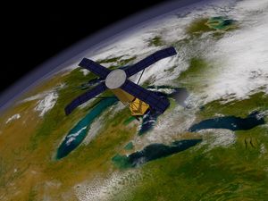
The Sea-viewing Wide Field-of-view Sensor (SeaWiFS) was an ocean-color instrument carried aboard OrbView-2 (formerly SeaStar), developed by Orbital Sciences Corporation and launched into low Earth orbit on August 1, 1997, using a Pegasus launch vehicle. SeaWiFS was the satellite’s only scientific payload, and after spacecraft and instrument commissioning, it started global data collection on September 18, 1997. Although originally designed for a minimum five-year mission, it operated successfully from 1997 to December 2010, when OrbView-2 lost communication with ground stations. The mission was formally concluded in February 2011. Over more than 13 years of operation, SeaWiFS produced one of the best continuous ocean biological records available to date.
SeaWiFS was designed to measure ocean color—specifically, the concentration of chlorophyll, the green pigment that enables photosynthesis in phytoplankton. From 1998 to 2010, it systematically mapped how “green” the oceans were. The mission’s primary objective was to obtain accurate, well-calibrated global ocean color data and convert them into meaningful biological parameters, such as photosynthesis rates, to better understand oceanic processes and their role in the global carbon cycle.
NASA purchased SeaWiFS data from Orbital Sciences. These data have been used in myriad applications. They helped clarify the magnitude and variability of chlorophyll and primary production by marine phytoplankton— microscopic marine plants that form the base of the ocean food web and play a central role in carbon uptake. Scientists could now track the timing of spring blooms (i.e., the time of highly abundant growth) and observe how phytoplankton populations respond to sunlight, nutrients, ocean currents, temperature, and climate patterns such as El Niño and La Niña. SeaWiFS data were also used for real-time monitoring of harmful algal blooms (red tides). They also provided crucial input to studies of ocean productivity, offering important insights into the role of ocean plants in carbon dioxide removal from the atmosphere and in linking marine ecosystems with climate variability. Finally, as a result of pre-launch modifications, SeaWiFS data were also used to measure vegetation indices on land, leading to the production of a first-of-its-kind global snapshot of Earth’s biosphere.
The legacy of SeaWiFS lives on in current ocean color instruments and missions. The scientific and technical experience gained from the SeaWiFS mission has been valuable preparation for the design and application of the Earth Observing System's Moderate Resolution Imaging Spectroradiometer (MODIS), the Joint Polar Satellite System’s (JPSS) Visible Infrared Imaging Radiometer Suite (VIIRS), and the Plankton, Aerosol, Cloud, ocean Ecosystem (PACE) mission.
Spacecraft and Instrument Details
SeaWiFS was the only instrument on the OrbView–2 (formerly SeaStar) spacecraft, which was built by Orbital Sciences Corporation. The spacecraft’s orbit allowed it to complete 14.5 pole-to-pole swaths of data each day and scan 90% of Earth’s surface every two days.
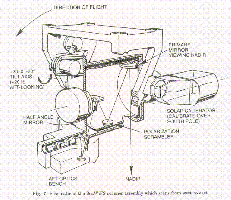
The SeaWiFS instrument consisted of an optical scanner and an electronics module (line drawing). It had scanning mechanisms that drove an off-axis folded telescope and rotating half angle mirror. The collected radiation was separated into four wavelength intervals—each of which encompassed two of the eight spectral bands of SeaWiFS, which were defined as follows:
| Instrument Bands | |
| Band | Wavelength |
| 1 | 402-422 nm |
| 2 | 433-453 nm |
| 3 | 480-500 nm |
| 4 | 500-520 nm |
| 5 | 545-565 nm |
| 6 | 660-680 nm |
| 7 | 745-785 nm |
| 8 | 845-885 nm |
Data Access
The SeaWiFS Project developed and operated a research data system that processed, calibrated, validated, archived, and distributed data received from an Earth-orbiting ocean color sensor. To learn more about SeaWiFS data, see: https://www.earthdata.nasa.gov/data/instruments/seawifs.
End of SeaWiFS
After 13 years of service, researchers are no longer able to communicate with SeaWiFS. This extremely important instrument, which gave scientists data on ocean color, filled in a vital information gap. Subtle changes in ocean color signify various types and quantities of marine phytoplankton (microscopic marine plants), the knowledge of which has both scientific and practical applications.
SeaWiFS Stories

Dr. Inia Soto Ramos became fascinated by the mysteries of the ocean while growing up in Puerto Rico’s mountains. Today,…
Key OrbView–2 (SeaWiFS) Facts The Sea-viewing Wide Field-of-view Sensor (SeaWiFS) was an ocean-color instrument carried aboard OrbView-2 (formerly SeaStar), developed…

A new satellite-derived dataset links concentrations of fine particulate matter in air pollution with health outcomes in cities around the…

How can snow cover on the Himalayas influence the species that thrive in the ocean a thousand kilometers away?

The floating plant-like organisms are showing up in higher concentrations across the Arctic Ocean.

In several decades of observing the ocean with satellites, our vision has changed as much as the sea.

By analyzing satellite images of sediments, coastal researchers and cartographers can identify potential shallows, shoals, and shipping hazards.

Improved data from several satellites illustrates how concentrations of fine particulate pollution have changed over time.

Airborne measurements detect the greenhouse gas rising out of cracks in the ice cap.

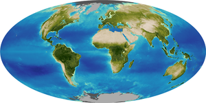
The image of SeaWiFS data as a global average over the entire 13-year record shows the greenness of Earth's oceans…
The sum of Earth's plants, on land and in the ocean, changes slightly from year to year as weather patterns…
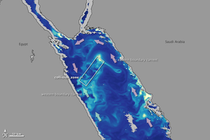
his image shows chlorophyll concentrations in the waters of the Red Sea observed by the Sea-viewing Wide Field-of-View Sensor (SeaWiFS)…


