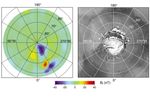
Photojournal NavigationSciencePhotojournalNorth Polar Magnetic Anomaly...Photojournal HomePhotojournal SearchLatest ContentGalleriesFeedbackRSSAbout 1 Min Read North Polar Magnetic Anomaly Map (MAG/ER) PIA02050 Credits: NASA/JPL/GSFC Image Addition Date:06/23/1999Target:MarsIs a satellite of:SunMission(s):MGS (Mars Global Surveyor)Spacecraft(s):Mars Global Surveyor (MGS)Instrument(s):MAG (Magnetometer)Dataset:MGS (Mars Global Surveyor) Downloads North Polar Magnetic Anomaly Map (MAG/ER) JPEG (208.71 KB) North Polar Magnetic Anomaly Map (MAG/ER) TIFF (1.85 MB) Description Radial magnetic field measured at about 170-km altitude over the North Polar Region with the corresponding image showing the North Polar Cap. Keep Exploring Discover More Topics From Photojournal Photojournal Search Photojournal Photojournal’s Latest Content Feedback