


Description
Context image
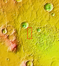
This VIS image shows part of Ariadnes Colles. The term colles means hills. The hills in this image are much brighter than the surroundings, possibly due to erosion or removal of the darker material from the upper elevations of the hills.
Orbit Number: 66840 Latitude: -33.9961 Longitude: 171.816 Instrument: VIS Captured: 2017-01-07 11:47
Please see the THEMIS Data Citation Note for details on crediting THEMIS images.
NASA's Jet Propulsion Laboratory manages the 2001 Mars Odyssey mission for NASA's Science Mission Directorate, Washington, D.C. The Thermal Emission Imaging System (THEMIS) was developed by Arizona State University, Tempe, in collaboration with Raytheon Santa Barbara Remote Sensing. The THEMIS investigation is led by Dr. Philip Christensen at Arizona State University. Lockheed Martin Astronautics, Denver, is the prime contractor for the Odyssey project, and developed and built the orbiter. Mission operations are conducted jointly from Lockheed Martin and from JPL, a division of the California Institute of Technology in Pasadena.


